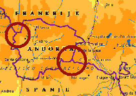
The tripoints of Andorra
The mini-state of Andorra in the Pyreneees has two tripoints with
France and Spain: east and west. In august 2001 I tried to photograph
both points. The western tripoint is clear enough: the summit of Pic de
Médecourbe. The eastern tripoint however has different spots on
different maps. I would like to thank Marcel Miquel for his
contributions into this question.
In july 2004 I visited both tripoints again. The pictures (including panorama's) can be seen at two separate webpages:
andorra-tripoint-west-2004.html
andorra-tripoint-east-2004.html
 Andorra is a tiny state of approx. 25x29 km. Charlemagne captured the
area from the muslims in 803. Later on it passed to a bishopric in
Catalunya. The counts of Foix (France) disputed the property and that
evolved in the 13th century into a system of shared sovereignty.
Nowadays Andorra survives quite well on ski-tourism and duty-free
shopping.
Andorra is a tiny state of approx. 25x29 km. Charlemagne captured the
area from the muslims in 803. Later on it passed to a bishopric in
Catalunya. The counts of Foix (France) disputed the property and that
evolved in the 13th century into a system of shared sovereignty.
Nowadays Andorra survives quite well on ski-tourism and duty-free
shopping.
The Andorran borders
The borders of Andorra are still -after all these centuries-
provisional. There's no overall agreement with either France or Spain.
The act of demarcation between France and Spain (1868) gives no
description of the French-Andorrran border. There's no border-treaty
known between Andorra and Spain, although there's a reference to a to a
mixed Andorran-Spanish commission who installed boundary markers around
1860.
The Andorran constitution (1993) states that the borderline is the
'traditional one'. Several maps contain the remark: "the Spain-Andorran
boundary line hasn't been officially sanctioned" or likewise.
However, in two areas Andorra and France came to a delimitation act.
The first is about the border of the Andorran parish of St. Julia de
Loria with Spain (1856). The second (2000) delimited the border near
the French village of Porta. Neither of these agreements comprises the
tripoints.
Between Andorra and Spain there is at least one disputed area: a zone
near the Montmalus peak.
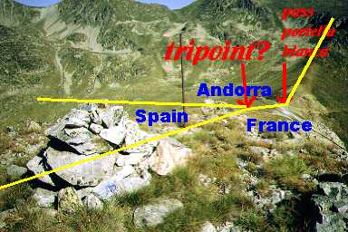
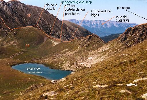
The eastern tripoint
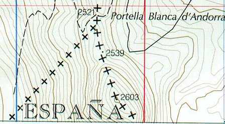
The eastern tripoint is not fixed at one spot. Different maps show
different places. Some show the tripoint exactly on the Portella
Blanca, a mountain pass between France and Andorra. This location is
endorsed by the French-Spanish border agreement. Other maps show the
tripoint a little to the south of Portella Blanca, on the 'saddle'
between a little and larger hill.
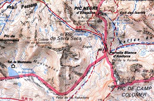
Overview from the French 1:50.000 map. The tripoint is here shown a little to the south of Portella Blanca.
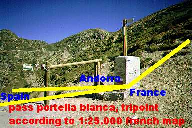
However: from the French-Spanish border agreement (1868): "From the Peak d'en Valira, situating at the crest of ther Pyrenees
between France and Andorre, [the boundary line] follows an abutment
south, and there meets a pass well known by the name of Coll d'en Gait
or Portella Blanca d'Andorra. Here marker 427 has been placed on the
northern edge of the path, at a point common to Spain, France, and
Andorra.
The borderline follows from marker 427 on the ridge of the same
abutment, climbing the peak called Tosseta de l'Esquella by the Spanish
and Camp Coloumer by the French. From this ridge....".
Probably this map is a mistake, all other French maps I've seen situate the tripoint at the pass.
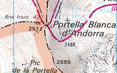
The French 1:25.000 map locates the tripoint at the pass as stated in the above citation.
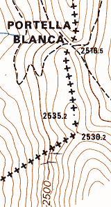
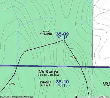
From the 1:10.000 map of Andorra, only the border of Andorra is drawn.
Where the border takes the direction south-west is the tripoint.
Clearly visible is the position on this map of the tripoint on the
'saddle' between the smaller and larger hill.
From the 1:10.000 Spanish map. Only the Spanish border is shown. The
tripoint is on this map on the pass but a little bit to the south-west.
From the 1:25.000 Spanish map with the same positioning of the tripoint as on the 1:10.000 map.
The pass Portella Blanca, seen from the south-east. This is the
tripoint according to the French maps en the French-Spanish
border-agreement. The Spanish maps situate the tripoint a little bit to
the south-west.
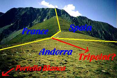
Picture taken from the pass to the south. We see first a smal hill,
then a larger one. The tripoint is in between according to the 1:10.000
map of Andorra. Behind the large hill starts a steep rocky mountain.
Picture taken from the top of the large hill in the direction of Portella Blanca.
And this is a picture from the North-East, supplied and explained by Marcel Miquel.
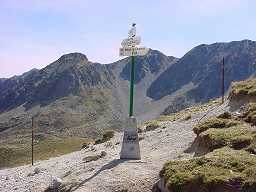
This 'Eurorando'-waymarker was placed in september 2001 on the Portella
Blanca by the mountainering association of Andorra. They consider the
pass being the tripoint. More pictures to be seen at this site
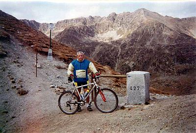
And one mountain biker worked his way up to the pass, as one can see at this site
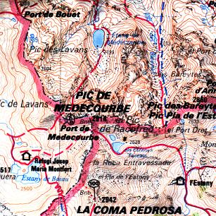
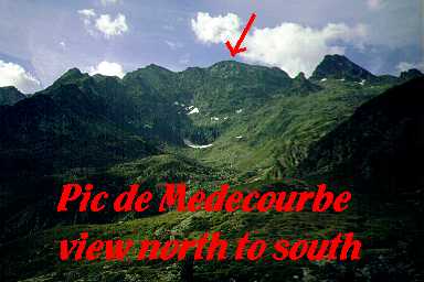
The western tripoint
This point is not disputed: it's the summit of Pic de Médecourbe, the
top of a sharp mountain ridge. According to the map crowned with a
border marker. I tried to reach this border marker from the pass Port
de Médecourbe but did not succeed. I climbed too much to the west and
got trapped on the sharp top ridge, unable to move to the east. Later I
found out that the summit is quite easily accessible for a plain
mountain walker but only when approached from the east. One day later I
found myself to the north of the Pic (in France) but the wind was too
strong to give it another try.
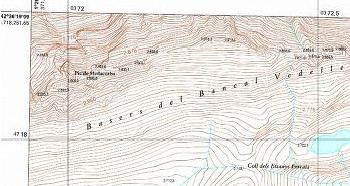
Overview from the French 1:50.000 map.. "Bne" just below means 'borne'
= (border) stone, indicating there's a border marker present. This is
however not border marker 426. The French-Spanish border agreement
(1868) states: "Boundary marker 426: at the Boet port, a cross 8 meters
away from the path.
After this point, the international line runs for a very short run
since reachs the Peak of Baiau or Nau de Baiau [ = Peak of Medacorba ],
common peak to Spain, France and Andorra and final point of this
delimitation act." However: I passed the Boet port and didn't find any
border marker.
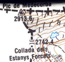
Detail of the Andorra 1:25.000 map.
From the
Pic de Medacorba Topomap 1:5.000. It strikes that the Pic de Médecourbe
(hardly readable) is situated more to the west then on the two above
maps.
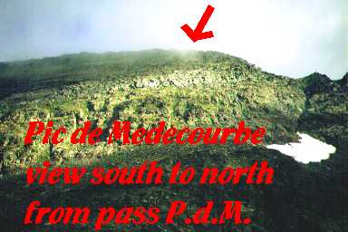
Picture taken from the pass Port de Médecourbe. The perspective regarding the summit might be a bit distorted.
Picture taken from France. With my binoculairs I could vaguely see a border marker on the top.
|