|
Before 1659
There have been many territorial changes in the Pyrenees in the
centuries preceding the Treaty of the Pyrenees of 1659. In most cases,
the Pyrenees proved to be a natural border between territorial entities
north and south. As far as we know there were no systematic
delimitations by bordermarkers.
Some treaties are important in this respect:
- 1258 Treaty of Corbeil: the kingdoms of France and Navarra settled
their division in the eastern Pyrenees, the border shifted to the north
of the current Pyrénées-Orientales.
- 1278 and 1288 Signing of the first and second "Paréage" of Andorra,
which arranged the joint sovereignty of Andorra by the Count of Foix
and the bishop of Urgell. That's how Andorra came into existence.
- 1375 Junte
de Roncal: a local treaty between the communities of the Baŕetous
valley and the Roncal valley on either side of the esfr-border on and
near Col de Saint-Martin (bm262). Following two years of mutual
bloodshed, the conflict about access to the only watersource on this
dry plateau (at the Spanish side of Pic d'Arlas) was settled. The
yearly ceremony on 13 july of the "Tribut de trois vaches" still exists.
- 1462-1493 Treaty of Bayonne: a temporary shift of Rousillon and
Cerdagna from Navarra to France in exchange for military aid to help
Navarra in the Catalonian civil war.
- 1513 "Le serment de Plan d'Arrem": a local treaty about cross-border
use of pastures, forests, sources, transport and mutual help between 19
French and Spanish communities in a wide area around Fos where the
treaty was signed. There were more of such local "Lies and passeries"
in the Pyrenees, providing stability and peace in these borderregions.
In the Bayonne demarcation treaties (1856-1868) some of them were
incorporated.
1641 Treaty of Péronne: giving the king of France the title of count of Barcelona, Cerdagne and Roussillon while these territories remained under the jurisdiction of Catalonia.
1659: Treaty of the Pyrenees
Louis XIV of France and Philippe IV of Spain agreed to this treaty
to end their 1635-1659 war. It was signed on an island in
the river Bidassoa near Hendaye, exact at the border. Known as the
"l'Île des Faisans" (and later "l'Île de la Conférence") it
was transformed in a condominium: a shared territory between
France and Spain.
Fixating
the border in the Pyrenees was only a part of this broad-range treaty.
However: the description of the borderline remained very vague. Article
42 states that the mountains of the Pyrenees will divide the two
kingdoms as it did between de French and Spanish tribes in the Roman
era.
However, a specification of the borderline was discussed in March 1660 in Céret by Spanish and French deputies. Roussilion
was lost by Spain The Cerdagne was divided, a division settled in
the Treaty of Llivia of 1660. Thirty-two villages became French but
Llivia - considered as a town - remained Spanish and turned
into an enclave in autumn 1660. There's no mention whatsoever of bordermarkers.
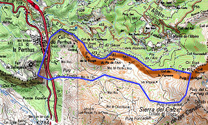 1764: Convention of Perpignan 1764: Convention of Perpignan
South of Perpignan - at and near the Col de Perthus - France and Spain
didn't agree about the exact borderline to be established after the
treaty of the Pyrenees. France claimed for historical reasons a
strip of territory south of the watershed as shown approximately on
this map with a blue line. After a century, France gave in and the
borderline was fixed as it is still today.
The treaty involved the placing of 10 bordermarkers:
- 2 pillar-like markers with a coat of arms of both countries at either
side of the main road from Perpignan passing through the Col de Perthus
into Spain (nowadays bm574 and 575)
- 4 pyramid-shaped markers around the Fort de Bellegarde to the west (nowadays bm567, 568, 570 and 571)
- 4 pyramid-shaped markers to the east (nowadays bm576, 577, 578 and 579).
In 1866 these markers were restored and incorporated in the 1 to 602 number sequence.
1785: Treaty of Elizonda: settling the Pays Quint disputes
In 1785 there was a first attempt to precisize the esfr-borderline
in the Treaty of Elizonda. Two French and Spanish military engineers
(the "Commision Internationale Caro-d'Ornano") were assigned with this
job.
 This
treaty was primarily meant to settle the border-disputes in the
valleys south of Saint-Étienne-de-Baïgorry. The so-called "ligne
d'Ornano" - two straight lines neglecting the watershed - was
established as the border in the valley of Baïgorry. This
line is first from bm130 straight to bm141 at the hilltop of
Ichterbegui and from there to bm155 at Col de Lindus. There were
special cross-border rules for the French and Spanish shepherds and
peasants. But the disputes went on. In the end, this culminated in 1856
in a special status for the part south of the Ornano-line: "le
pays Quint". See esfr-html-curiosities.html This
treaty was primarily meant to settle the border-disputes in the
valleys south of Saint-Étienne-de-Baïgorry. The so-called "ligne
d'Ornano" - two straight lines neglecting the watershed - was
established as the border in the valley of Baïgorry. This
line is first from bm130 straight to bm141 at the hilltop of
Ichterbegui and from there to bm155 at Col de Lindus. There were
special cross-border rules for the French and Spanish shepherds and
peasants. But the disputes went on. In the end, this culminated in 1856
in a special status for the part south of the Ornano-line: "le
pays Quint". See esfr-html-curiosities.html
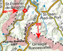 The
treaty was accompanied by a "procés-verbal" describing 197 - unnumbered
- borderstones and -crosses from Col d'Ispéguy (current bordermarker 91) to Col d'Arnostéguy (current bm205). The
treaty was accompanied by a "procés-verbal" describing 197 - unnumbered
- borderstones and -crosses from Col d'Ispéguy (current bordermarker 91) to Col d'Arnostéguy (current bm205).
In fact, there were two "procès-verbaux":
1. (between august 29th and september 8th 1785) describing the 162 bordermarkers from 'Beorzu' until Col d'Arnostéguy ( from west to east)
2. (september 21th and 22th 1785) describing the 35 bordermarkers from 'Beorzu' until Col d'Izpeguy (from east to west).
Robert Darrieumerlou concludes in this article (in French)
that 'Beorzu' must have been a location slightly to the west of
the hilltop of Harguibel, not far from the current bm126. He considers
the delimitation of 1785 as more precise (using 197 bordermarkes) than the one of 1856 (114 bordermarkers). The old spots and crosses were used for the new bordermarkers.
1785: Treaty of Elizonda: bordermarkers 1-130 installed
 The
delimitation-efforts of the Caro-d'Ornano-commission didn't stop with
the above settlement of the Pays Quint-disputes. They went on to
demarcate the borderline west of the Pays Quint - from the Atlantic
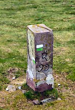
coast Col d'Ispeguy and placed the bordermarkers 1 to 130. They were incorporated 71 years later in the Bayonne treaties. A lot of these bordermarkers still exist and are well recognizable by the capital R above the number and the demarcation line of direction at their top. The
delimitation-efforts of the Caro-d'Ornano-commission didn't stop with
the above settlement of the Pays Quint-disputes. They went on to
demarcate the borderline west of the Pays Quint - from the Atlantic
coast Col d'Ispeguy and placed the bordermarkers 1 to 130. They were incorporated 71 years later in the Bayonne treaties. A lot of these bordermarkers still exist and are well recognizable by the capital R above the number and the demarcation line of direction at their top.
The
demarcation-job E of Pays Quint was however suspended in 1792 or 1793,
due to the political situation and the difficulties encountered in the
mountainous terrain (see this article)
1856-1868: the Bayonne treaties
These treaties are still the foundation of the present delimitation of
the French-Spanish border. The objective was "to determine more
precisely the border and to resolve difficulties encountered since 200
years". That job was performed so well that there have been only
minor changes and adjustments ever since.
There are 3 major treaties and one minor about Llivia.
1856: the first one describes the borderline and the bordermarkers between the Atlantic ocean and the mountaintop of "table des trois rois". That's the tripoint where France, Aragon and Navarra meet. It includes the bordermarkers 1 to 272.
1862: the second one continues to Andorra to its western tripoint on Pic de Médecourbe, from bordermarker 273 to 426.
1866: the third one covers the last section from the eastern tripoint of Andorra at la portella Blanca to the Mediterranean coast. That is from bordermarker 427 to 602.
1868: the Spanish enclave Llivia received its own delimitation agreement and set of bordermarkers.
Note that there has never been an overall delimitation agreement
between Andorra & France (and Andorra & Spain).
Andorra shares only one bordermarker with his neighbors, that's bm427 at its eastern tripoint.
After 1868
1875: establishment of the "Commission Internationale des Limites" - later "Commission Internationale de Pyrénées"- , charged with the application of the treaties mentioned above. See the bm maintenance-page for more information on how inspection and maintenance were organized in later years.
As said before, there have been minor changes and adjustments since the Bayonne treaties. We can draw up this list:
-14 submarkers of bm044, placed in 1988 (see esfr-html-bibliography-treaties.html)
-on the Port de Larrau: 237b BIS
-adjustments along the road to Arette in 1985, concerning bm258 and 259 (see esfr-html-bibliography-treaties.html)
-the BIS-pillar at Col de Somport: 305 BIS
-4 submarkers of bm408, placed in 1969
-these 4 submarkers becoming obsolete in 2015 because of a proposed borderchange between bm408 and 409
-14 submarkers of bm409, placed in 1970 or shortly later
-bm420bis, added in 1997 (see esfr-html-curiosities.html
-bm422bis, added in 1963
-bm467/1 and bm467/2, on eitherside of the railway Puigcerda - La-Tour-de-Carol, date unknown
-bm481: together with bm482 replaced in 1996 by a bronze plate in the tarmac, see this treaty concerning bm481
-bm567bis near Le Perthus, date unknown
-BIS-plate in the tarmac-surface in Le Perthus: 574 BIS
-bm579bis beyond Le Perthus, probably placed in 1906
-the BIS-pillar at the mediterranean coast: 601BIS
2019
Andorra and France installed 6 bordermarkers on their border south of Pas de la Casa. See this page.
|
