|
The
bordermarkers of the Pyrenees : the GRPdesBF
 |
||||||||||||||||||||||||||||||||||||||||||||||||||||||||||||||||||||||||||||||||||||||||||||||
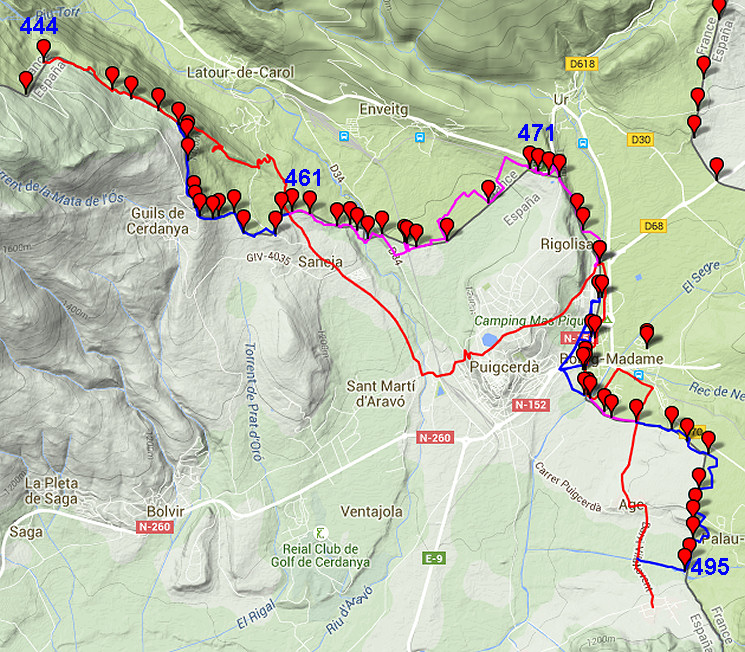
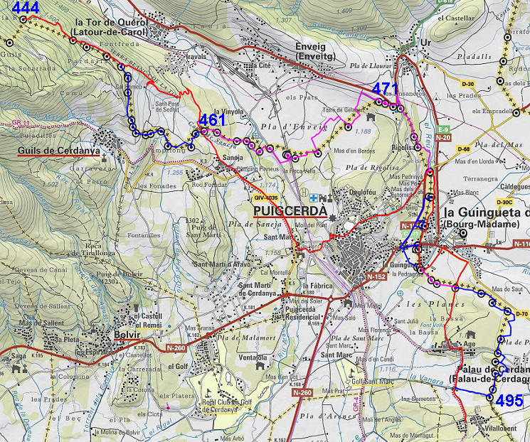
| - stage 42 - Pla Llauró - Vilallovent (bm444-495) |
 |
|||||||||||||||||||||||||||||||||||||||||||||||||||||||||||||||||||||||||||||||||||||||||||||
 |
||||||||||||||||||||||||||||||||||||||||||||||||||||||||||||||||||||||||||||||||||||||||||||||
| Only
the bordermarkers along this stage are shown (and some adjoining ones).
The main route is red,
the variants have other colors. The main route provides a smooth
on-going route passing along many bordermarkers, the variants give access to
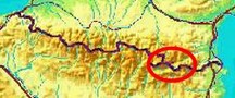
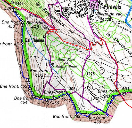
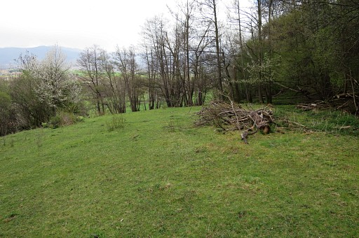
the remaining bordermarkers. See the GRPdesBF-principles. Click here for an fullscreen interactive map. In short This stage - traversing the Cerdagne-plains and passing between Puigcerdà and Bourg-Madame - is the one with the most bordermarkers of the whole GRPdesBF! If you combine it with the Llivia-circuit, you can cover 115 bordermarkers in two days. But most of these bordermarkers are on the 5 alternatives because many are located on private property (usually unfenced fields). The main route restricts itself - in principle - to public trails and roads. But with the detailed maps on this page (see also: Print your own maps), wayfinding is not difficult. NB: the next stage is the Llivia-circuit which - as a whole - is an alternative and not part of the main route. If you want to include the Llivia-bordermarkers, it makes more sense to do that while you're still near Puigcerdà. That means: breaking up this stage in two parts. For example: - day 1: doing bm44-477 in this stage, walk to the Llivia-border along the D68 and continuing with the first half of the Llivia-circuit - day 2: doing the second half of the Llivia-circuit, walk back to the main border and continue with bm478-495 Considerations As said before: many bordermarkers are on or along private fields. Usually no one will care if you visit them, as long as you are respectful to fences, crops and cattle. However, three bordermarkers do present problems in this respect: - bm480fr: nowadays standing in a high-fenced terrain but visible from the outside - bm481fr: in the private playgarden of a children's home but well visible from the street - bm482es: standing in a private garden of a deserted villa, hidden by bush. Puigcerda provides hotels, Entveig and Bourg-Madame camping-sites. At the end of this stage - in Vilallobent - it's a short walk into France to a camping. A bivouac is not an easy option in this densely populated area but around bm495 it's more quiet and sheltered. Factsheet
Gps-files needed
Useful You might check the relevant webpages in the 'All markers'-section and 'All my trips'-section. They provide pictures of the bordermarkers and additional information. Version 03 May 2015. If you have any correction, suggestion etcetera -> please email me: eefberns@grenspalen.nl MAPS AND DIRECTIONS Print your own maps It's easy to print your own - custom made - maps with the GRPdesBF-route and the bordermarkers on them. See: Print your own maps |
||||||||||||||||||||||||||||||||||||||||||||||||||||||||||||||||||||||||||||||||||||||||||||||
 |
||||||||||||||||||||||||||||||||||||||||||||||||||||||||||||||||||||||||||||||||||||||||||||||
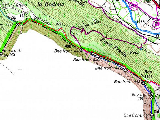 |
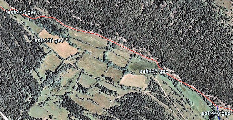
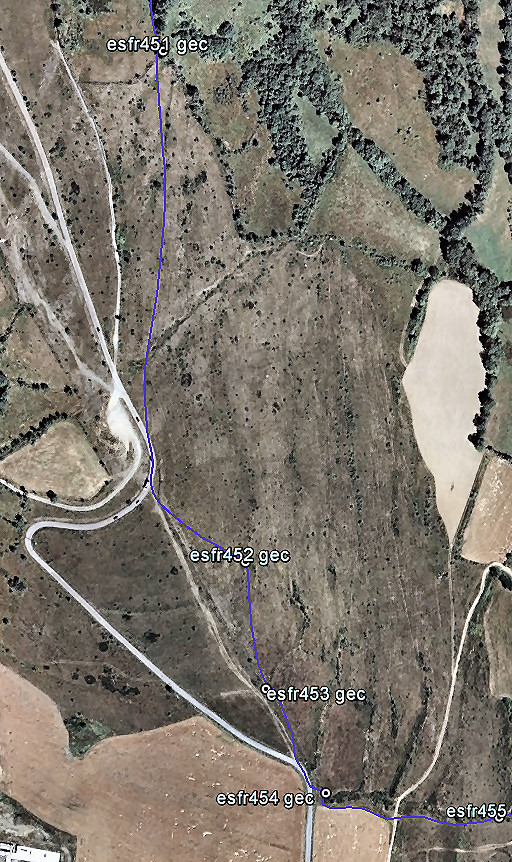
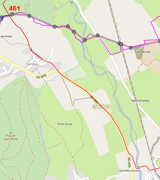
The first part: from bm444 to bm448. |
|||||||||||||||||||||||||||||||||||||||||||||||||||||||||||||||||||||||||||||||||||||||||||||
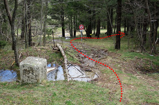 |
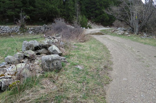
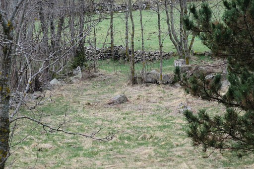
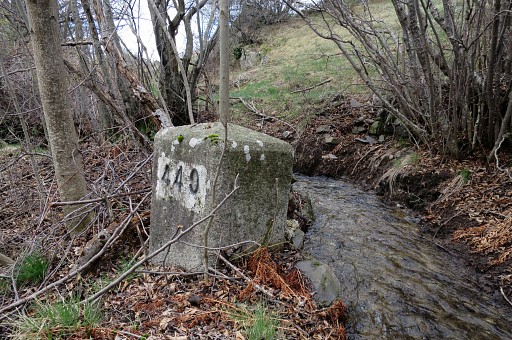
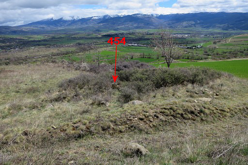
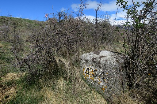
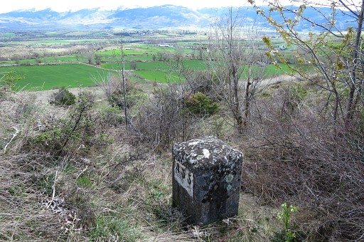
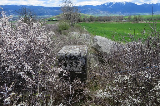
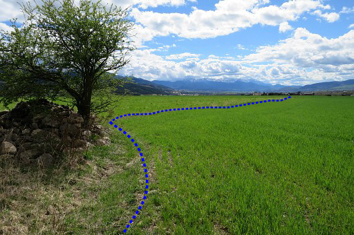
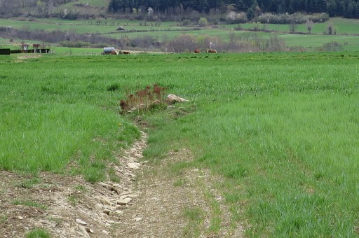
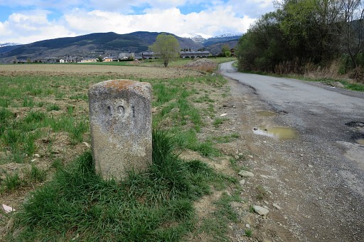
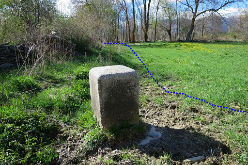
This is your starting point: bm444. To go from bm444 to 445: pass through the fence-gate and go right, heading E along cq parallel to the stream & fence. There are some cattle trails to help you. |
|||||||||||||||||||||||||||||||||||||||||||||||||||||||||||||||||||||||||||||||||||||||||||||
 |
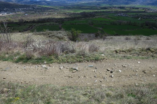
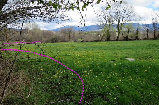
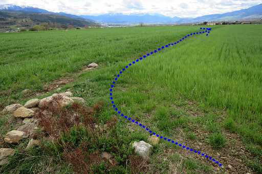
After 400m you will get to a dirtroad which further E (after 500m) arrives at this meadow to the left. | |||||||||||||||||||||||||||||||||||||||||||||||||||||||||||||||||||||||||||||||||||||||||||||
|
Bm445 is further on at the first bend where the dirtroad makes two bends. | |||||||||||||||||||||||||||||||||||||||||||||||||||||||||||||||||||||||||||||||||||||||||||||
 |
||||||||||||||||||||||||||||||||||||||||||||||||||||||||||||||||||||||||||||||||||||||||||||||
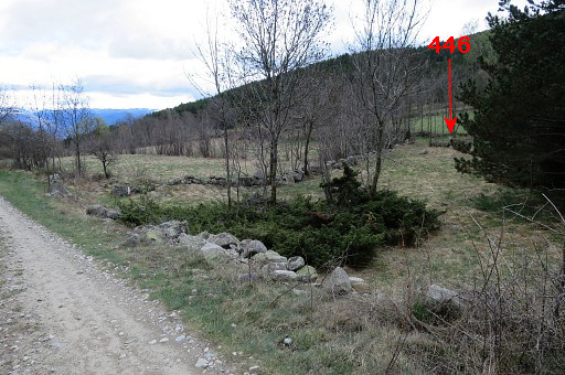 |
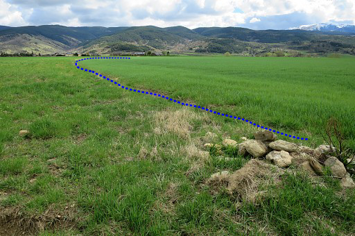
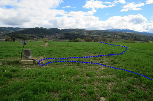
Then the dirtroad passes through a piece of forest and a meadow appears at your right hand. That's here. Bm446 is a short stretch from the dirtroad and in this season well visible from the dirtroad. |
|||||||||||||||||||||||||||||||||||||||||||||||||||||||||||||||||||||||||||||||||||||||||||||
|
Bm446 is ± 50m from the dirtroad. |
|||||||||||||||||||||||||||||||||||||||||||||||||||||||||||||||||||||||||||||||||||||||||||||
|
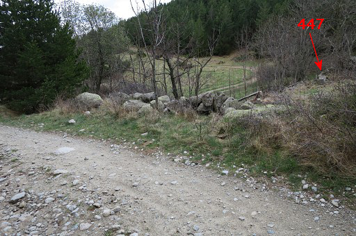
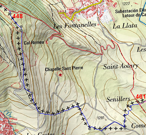
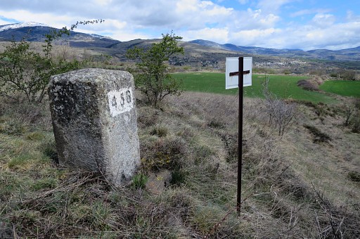
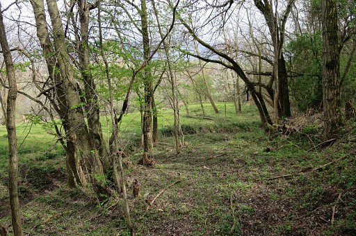
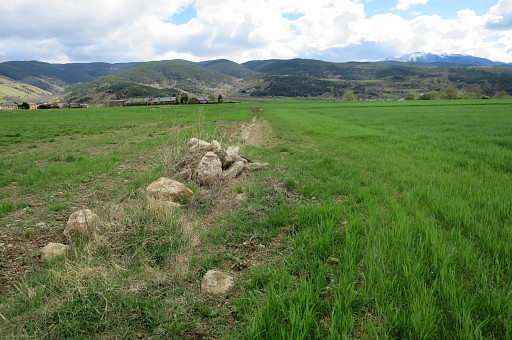
Bm447 is 400m further along the dirtroad, also at a little distance of the dirtroad. It's where a branch of the dirtroad goes right and bm447 is well visible from the dirtroad (in this season). Back to the dirtroad and continuing 25om until |
|||||||||||||||||||||||||||||||||||||||||||||||||||||||||||||||||||||||||||||||||||||||||||||
 |
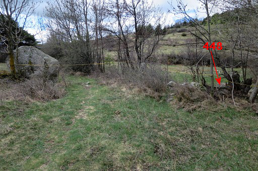
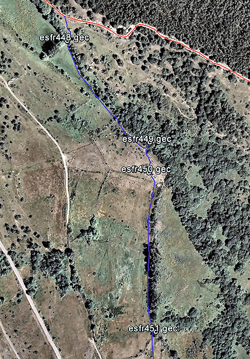
the dirtroad bends to the left. That's here. Bm449 is to the right but not visible from the dirtroad. This is also where variant 1 starts. |
|||||||||||||||||||||||||||||||||||||||||||||||||||||||||||||||||||||||||||||||||||||||||||||
 |
Let's zoom in and show where you can find bm449 Bm448 is ± 30m from the dirtroad. Bm448 stands at the other side of a stream. |
|||||||||||||||||||||||||||||||||||||||||||||||||||||||||||||||||||||||||||||||||||||||||||||
 |
The main route (red) continues on the dirtroad which becomes after two sharp bends a tarmac road. | |||||||||||||||||||||||||||||||||||||||||||||||||||||||||||||||||||||||||||||||||||||||||||||
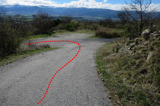 |
Then - here - another set of bends appears and |
|||||||||||||||||||||||||||||||||||||||||||||||||||||||||||||||||||||||||||||||||||||||||||||
 |
then a trail branches off to the right to proceed to Saneja. | |||||||||||||||||||||||||||||||||||||||||||||||||||||||||||||||||||||||||||||||||||||||||||||
 |
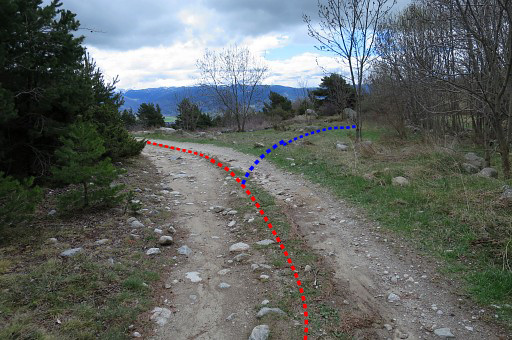
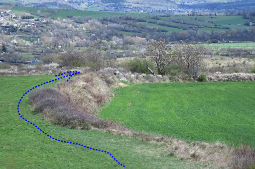
This map shows better the course of the main route and where it takes the trail leading to Saneja. That trail becomes a dirtroad and after 400m you will arrive at the junction with variant 1 and 2. |
|||||||||||||||||||||||||||||||||||||||||||||||||||||||||||||||||||||||||||||||||||||||||||||
| Variant 1 via bm449-559 | ||||||||||||||||||||||||||||||||||||||||||||||||||||||||||||||||||||||||||||||||||||||||||||||
 |
This variant mainly crosses fields. Giving directions is less useful now. Navigating with Google Earth-maps is easier. |
|||||||||||||||||||||||||||||||||||||||||||||||||||||||||||||||||||||||||||||||||||||||||||||
 |
The hedges in the terrain makes orientation and navigating quite easy. |
|||||||||||||||||||||||||||||||||||||||||||||||||||||||||||||||||||||||||||||||||||||||||||||
 |
Bm448. Proceed S-SE along the stream at its W-side towards bm449 for ± 200m. |
|||||||||||||||||||||||||||||||||||||||||||||||||||||||||||||||||||||||||||||||||||||||||||||
 |
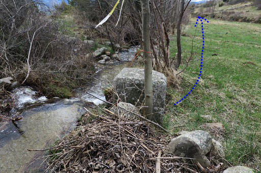
There's dense bush along the stream but where bm449 stands, you can descend easily. |
|||||||||||||||||||||||||||||||||||||||||||||||||||||||||||||||||||||||||||||||||||||||||||||
|
Bm449, looking uphill from where you have descended to reach this bm. From bm449 it's a short climb S or better SSE (50m) to |
|||||||||||||||||||||||||||||||||||||||||||||||||||||||||||||||||||||||||||||||||||||||||||||
|
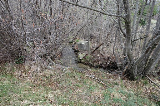
Bm450 It might be a bit difficult to spot it between the rocks lying in the field. Now cross the stone wall and continue S on the W-side of the hedge to bm451 |
|||||||||||||||||||||||||||||||||||||||||||||||||||||||||||||||||||||||||||||||||||||||||||||
 |
Bm451, in the corner of the next field (250m from bm450) From bm451 head S towards a big tree, visible on this picture. |
|||||||||||||||||||||||||||||||||||||||||||||||||||||||||||||||||||||||||||||||||||||||||||||
 |
The next part of this variant, still traversing the fields |
|||||||||||||||||||||||||||||||||||||||||||||||||||||||||||||||||||||||||||||||||||||||||||||
 |
At that tree, a track appears at the left side which ends 200m further | |||||||||||||||||||||||||||||||||||||||||||||||||||||||||||||||||||||||||||||||||||||||||||||
 |
at a tarmac road where | |||||||||||||||||||||||||||||||||||||||||||||||||||||||||||||||||||||||||||||||||||||||||||||
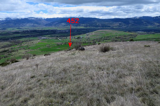 |
bm452 is SE in the field. Head straight through the field to |
|||||||||||||||||||||||||||||||||||||||||||||||||||||||||||||||||||||||||||||||||||||||||||||
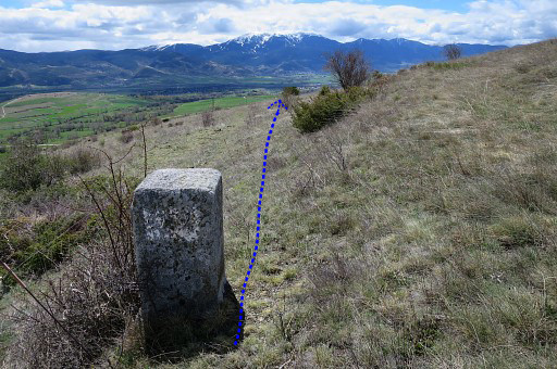 |
bm452 Then along a fence going S towards bm453 |
|||||||||||||||||||||||||||||||||||||||||||||||||||||||||||||||||||||||||||||||||||||||||||||
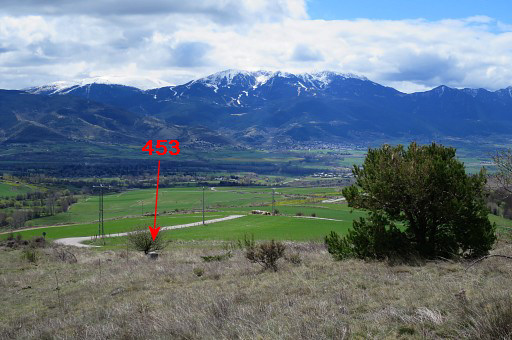
|
which becomes visible on this picture. | |||||||||||||||||||||||||||||||||||||||||||||||||||||||||||||||||||||||||||||||||||||||||||||
|
Bm453 Shortly afterwards you will join the road again (visible on this picture) |
|||||||||||||||||||||||||||||||||||||||||||||||||||||||||||||||||||||||||||||||||||||||||||||
 |
||||||||||||||||||||||||||||||||||||||||||||||||||||||||||||||||||||||||||||||||||||||||||||||
 |
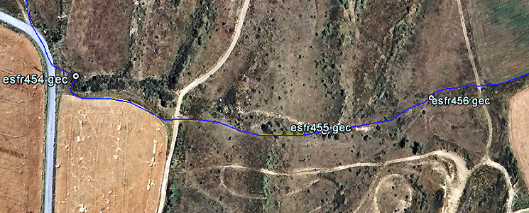
and on this road, leave it immediately again to search for bm454 | |||||||||||||||||||||||||||||||||||||||||||||||||||||||||||||||||||||||||||||||||||||||||||||
 |
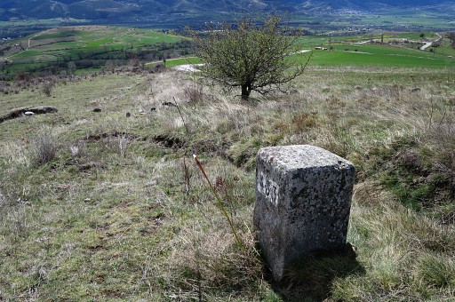
Bm454 might be difficult to spot and reach in the pricky bush. |
|||||||||||||||||||||||||||||||||||||||||||||||||||||||||||||||||||||||||||||||||||||||||||||
 |
Bm454, looking back towards the road. You can spot the traffic sign. Now the borderline descends E in a sort of ditch or trench, full with pricky undergrowth. So you'd better descend on the S-side of the trench along a field-edge |
|||||||||||||||||||||||||||||||||||||||||||||||||||||||||||||||||||||||||||||||||||||||||||||
|
and then pass this dirtroad | |||||||||||||||||||||||||||||||||||||||||||||||||||||||||||||||||||||||||||||||||||||||||||||
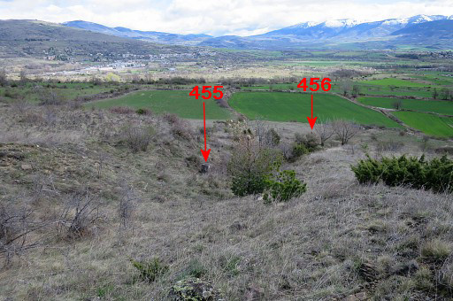 |
and find bm455 further in the ditch. Both bm455 and 456 are already visible in the distance. |
|||||||||||||||||||||||||||||||||||||||||||||||||||||||||||||||||||||||||||||||||||||||||||||
 |
Zoom-in to bm456 | |||||||||||||||||||||||||||||||||||||||||||||||||||||||||||||||||||||||||||||||||||||||||||||
|
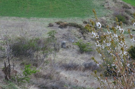
But first bm455 From here, go 75m to the NEE to reach |
|||||||||||||||||||||||||||||||||||||||||||||||||||||||||||||||||||||||||||||||||||||||||||||
|
bm456. |
|||||||||||||||||||||||||||||||||||||||||||||||||||||||||||||||||||||||||||||||||||||||||||||
 |
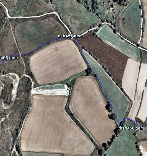
Zooming-in to the field to cross NEE to get to a dirtroad and bm457. |
|||||||||||||||||||||||||||||||||||||||||||||||||||||||||||||||||||||||||||||||||||||||||||||
 |
The next part of the route. |
|||||||||||||||||||||||||||||||||||||||||||||||||||||||||||||||||||||||||||||||||||||||||||||
 |
This picture: having arrived at the dirtroad, bm457 is immediately to the right but hidden in the bush. | |||||||||||||||||||||||||||||||||||||||||||||||||||||||||||||||||||||||||||||||||||||||||||||
|
Bm457, looking S From here SSE along a field-edge: take the right field-edge (see map above)! |
|||||||||||||||||||||||||||||||||||||||||||||||||||||||||||||||||||||||||||||||||||||||||||||
|
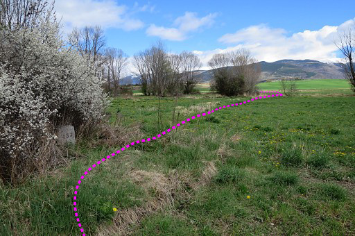
Bm458 is in the S-corner of the field (this picture: looking back) Then 25m NNE, getting out of the field and going SE on a dirtroad |
|||||||||||||||||||||||||||||||||||||||||||||||||||||||||||||||||||||||||||||||||||||||||||||
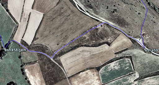 |
which this map shows. |
|||||||||||||||||||||||||||||||||||||||||||||||||||||||||||||||||||||||||||||||||||||||||||||
 |
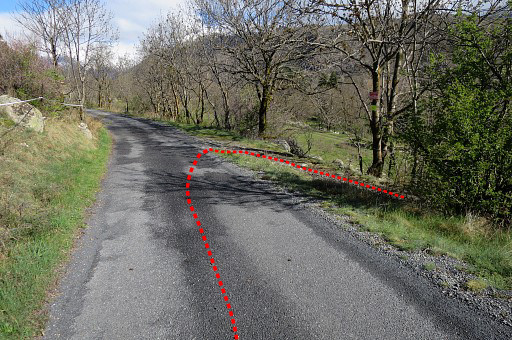
After 150m on that dirtroad, go left (that's here, be attentive not to miss it) on a vaguer dirtroad to connect (after 150m) with a more distinct dirtroad. | |||||||||||||||||||||||||||||||||||||||||||||||||||||||||||||||||||||||||||||||||||||||||||||
|
Then, bm459 is 125m to the right. | |||||||||||||||||||||||||||||||||||||||||||||||||||||||||||||||||||||||||||||||||||||||||||||
 |
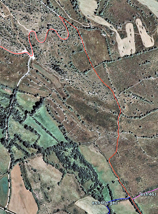
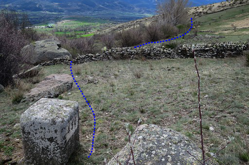
Now, from bm459, cross the dirtroad and enter NNW a field. Getting to 560 is a bending descent through the fields (this GE-map shows that well). Beyond bm460, you will join the main route again. Bm460 is within a 100m reach of the main route and is therefore a part of the main route. At the other side of the road, the next variant starts rightaway but bm461 is formally also part of the main route. |
|||||||||||||||||||||||||||||||||||||||||||||||||||||||||||||||||||||||||||||||||||||||||||||
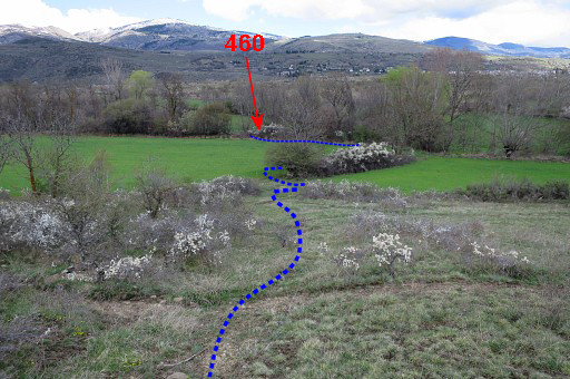 |
This picture: having descended and already having made the first bend. In the distance, you can already see the spot of bm460. |
|||||||||||||||||||||||||||||||||||||||||||||||||||||||||||||||||||||||||||||||||||||||||||||
 |
Bm460 is at the division of two meadows ahead. |
|||||||||||||||||||||||||||||||||||||||||||||||||||||||||||||||||||||||||||||||||||||||||||||
 |
The last stretch of this variant. |
|||||||||||||||||||||||||||||||||||||||||||||||||||||||||||||||||||||||||||||||||||||||||||||
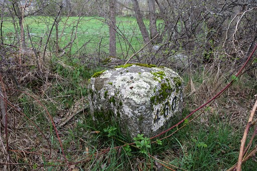 |
Bm460, hidden in the bush and probably difficult to reach in the summer. This picture: looking towards the meadow SEE. From bm460 proceed NEE on the N-side of the meadow-division and reach the dirtroad between bm460 and 461. |
|||||||||||||||||||||||||||||||||||||||||||||||||||||||||||||||||||||||||||||||||||||||||||||
| End of variant 1 |
||||||||||||||||||||||||||||||||||||||||||||||||||||||||||||||||||||||||||||||||||||||||||||||
|
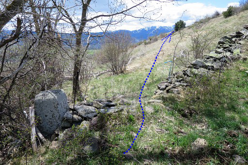
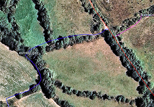
As said before: both bm460 and 461 are within a 100m reach of the main route. So technically and statistically they are part of the main route. This map shows how to reach bm460 and 461 from the main route. |
|||||||||||||||||||||||||||||||||||||||||||||||||||||||||||||||||||||||||||||||||||||||||||||
|
|
Bm460, hidden in the bush and probably difficult to reach in the summer. This picture: looking towards the meadow SE. |
|||||||||||||||||||||||||||||||||||||||||||||||||||||||||||||||||||||||||||||||||||||||||||||
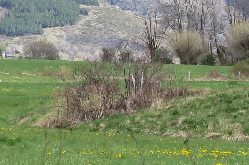
|
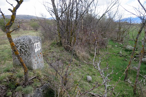
Bm461, standing in a hedge. |
|||||||||||||||||||||||||||||||||||||||||||||||||||||||||||||||||||||||||||||||||||||||||||||
 |
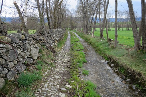
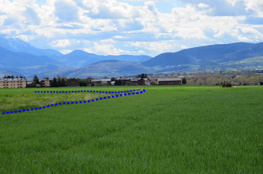
The main route now continues straight on to the village of Saneja. Then - after 1,5km on a more busy road - you can turn left to cross the river and the railway. |
|||||||||||||||||||||||||||||||||||||||||||||||||||||||||||||||||||||||||||||||||||||||||||||
 |
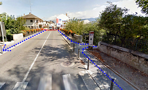
This map shows how to cross Puigcerda. Don't hesitate to visit the old center of Puigcerda which is lovely and offers bars, shops etcetera. And if your are interested: you can make a short detour N to visit the first crossborder or binational hospital in Europe: the "hôpital de Cerdagne" or "Hospital de Cerdanya". It's where the red cross is. |
|||||||||||||||||||||||||||||||||||||||||||||||||||||||||||||||||||||||||||||||||||||||||||||
 |
After passing a camping at your right hand, you will arrive at the N154. Cross it and take the old road at the other side towards the two bridges over the river Rahur. Shortly before them, variant 2 will join the main route. |
|||||||||||||||||||||||||||||||||||||||||||||||||||||||||||||||||||||||||||||||||||||||||||||
| Variant 2 via bm462-466 | ||||||||||||||||||||||||||||||||||||||||||||||||||||||||||||||||||||||||||||||||||||||||||||||
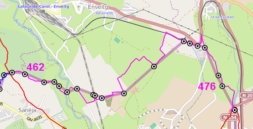 |
The same story as with variant 1: the route is mainly crossing fields and fences. Directions won't help you much. The Google Earth-maps hereunder are more useful. |
|||||||||||||||||||||||||||||||||||||||||||||||||||||||||||||||||||||||||||||||||||||||||||||
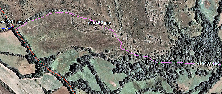 |
||||||||||||||||||||||||||||||||||||||||||||||||||||||||||||||||||||||||||||||||||||||||||||||
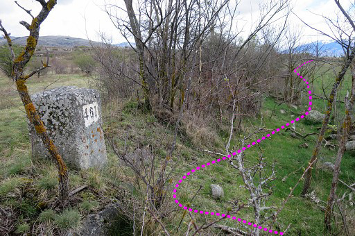 |
bm461 is less than 100m from the dirtroad and standing in a hedge. This picture: looking forward in the direction of bm462. |
|||||||||||||||||||||||||||||||||||||||||||||||||||||||||||||||||||||||||||||||||||||||||||||
|
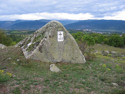
Just follow the hedge/fence and then bm462 is ±250m further on. From bm462 continue SE and descend along a stone wall cq fence. |
|||||||||||||||||||||||||||||||||||||||||||||||||||||||||||||||||||||||||||||||||||||||||||||
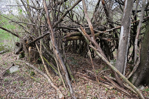 |
The slope becomes a sort of ridge and you will pass this 'cabin' before |
|||||||||||||||||||||||||||||||||||||||||||||||||||||||||||||||||||||||||||||||||||||||||||||
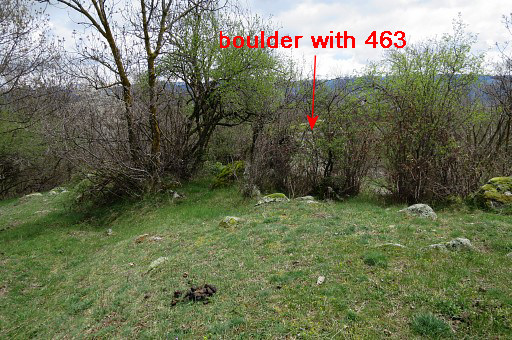 |
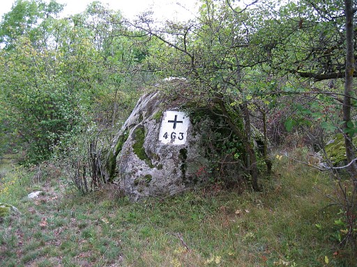
arriving at bm463. Bm463 is also engraved on a boulder but a smaller boulder than the one of bm462. It's hidden behind a bush and in summertime you might miss it alltogether. |
|||||||||||||||||||||||||||||||||||||||||||||||||||||||||||||||||||||||||||||||||||||||||||||
|
The number is on the other side. |
|||||||||||||||||||||||||||||||||||||||||||||||||||||||||||||||||||||||||||||||||||||||||||||
 |
||||||||||||||||||||||||||||||||||||||||||||||||||||||||||||||||||||||||||||||||||||||||||||||
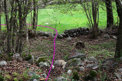 |
Now continue E-SE and cross this - no longer used - dirtroad with stone walls on either side. | |||||||||||||||||||||||||||||||||||||||||||||||||||||||||||||||||||||||||||||||||||||||||||||
 |
Then enter this meadow and go left and enter the adjacent meadow. Then go E until the end of the meadow where |
|||||||||||||||||||||||||||||||||||||||||||||||||||||||||||||||||||||||||||||||||||||||||||||
 |
an irrigation canal blocks your way but a small bridge will help you to cross it. |
|||||||||||||||||||||||||||||||||||||||||||||||||||||||||||||||||||||||||||||||||||||||||||||
|
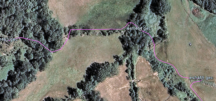
Bm464 is ± 20 m E of the bridge, in the bush. |
|||||||||||||||||||||||||||||||||||||||||||||||||||||||||||||||||||||||||||||||||||||||||||||
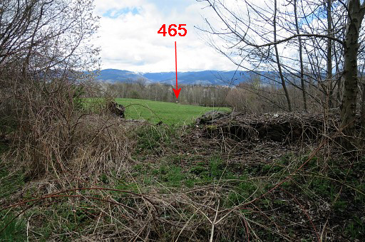 |
A bit further to the E, there's another meadow and | |||||||||||||||||||||||||||||||||||||||||||||||||||||||||||||||||||||||||||||||||||||||||||||
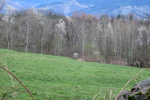 |
you can already spot bm465 to the SE. There's a steep stone-wall to jump from to get into the meadow. If you make a little detour to the NE, then access to the meadow is easier. |
|||||||||||||||||||||||||||||||||||||||||||||||||||||||||||||||||||||||||||||||||||||||||||||
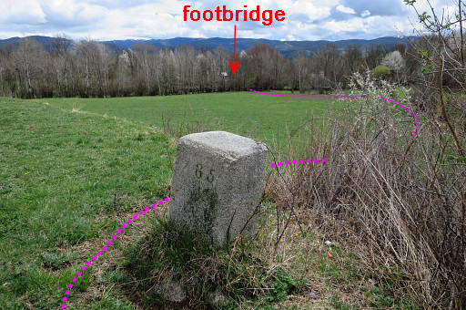
|
Bm465 From bm465, head SSE to the river and a footbridge. |
|||||||||||||||||||||||||||||||||||||||||||||||||||||||||||||||||||||||||||||||||||||||||||||
 |
||||||||||||||||||||||||||||||||||||||||||||||||||||||||||||||||||||||||||||||||||||||||||||||
 |
You can cross the river | |||||||||||||||||||||||||||||||||||||||||||||||||||||||||||||||||||||||||||||||||||||||||||||
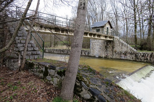 |
on this footbridge. | |||||||||||||||||||||||||||||||||||||||||||||||||||||||||||||||||||||||||||||||||||||||||||||
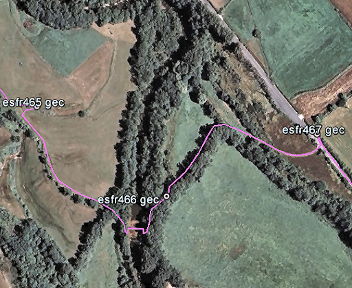
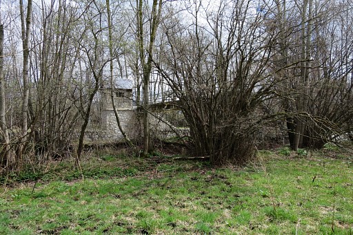
 |
Bm466 is on the other side, 50m the NE, near the ford which is just N of the footbridge. | |||||||||||||||||||||||||||||||||||||||||||||||||||||||||||||||||||||||||||||||||||||||||||||
|
Bm466 This shows the position of bm466 better: you can see the river where the ford is, just N of the footbridge. From here I follow the hedge NE at its N-side and arrive at a dirtroad which climbs SE to |
|||||||||||||||||||||||||||||||||||||||||||||||||||||||||||||||||||||||||||||||||||||||||||||
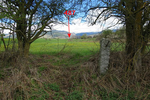
|
this road. To the left is bm467 and a peculiar and rather unique milestone. |
|||||||||||||||||||||||||||||||||||||||||||||||||||||||||||||||||||||||||||||||||||||||||||||
 |
||||||||||||||||||||||||||||||||||||||||||||||||||||||||||||||||||||||||||||||||||||||||||||||
 |
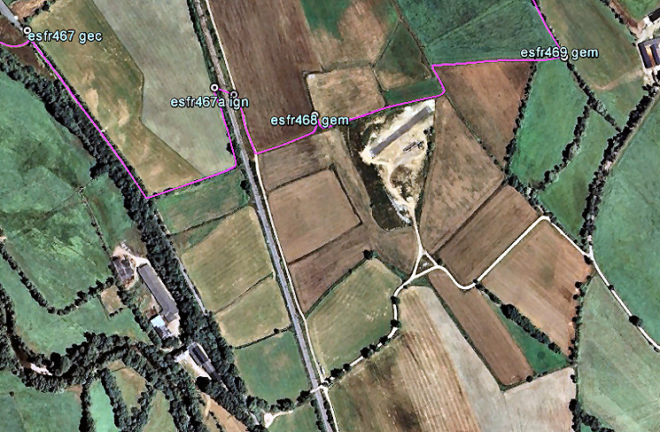
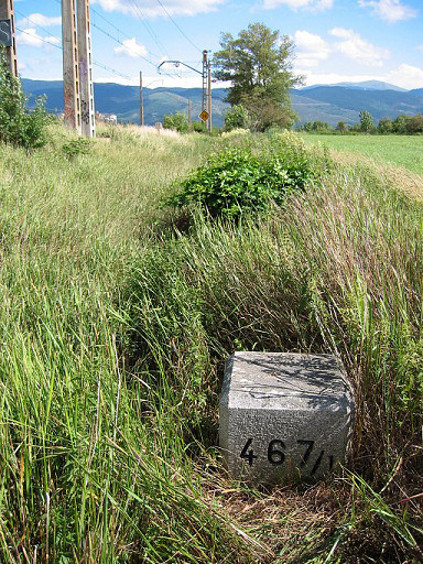
Now follow road and field-edges as indicated above. Bm467/1 is at the W-side of the railway, about here. |
|||||||||||||||||||||||||||||||||||||||||||||||||||||||||||||||||||||||||||||||||||||||||||||
|
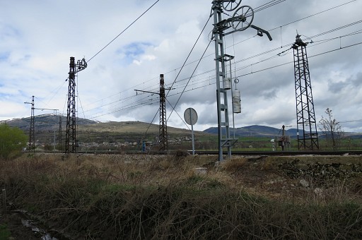
Bm467/1 The groove at its top is pointing to bm466 (and bm467/2 at the other side of the railway) Cross the railway |
|||||||||||||||||||||||||||||||||||||||||||||||||||||||||||||||||||||||||||||||||||||||||||||
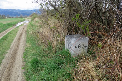
|
to find bm467/2 diagonally at the other side. |
|||||||||||||||||||||||||||||||||||||||||||||||||||||||||||||||||||||||||||||||||||||||||||||
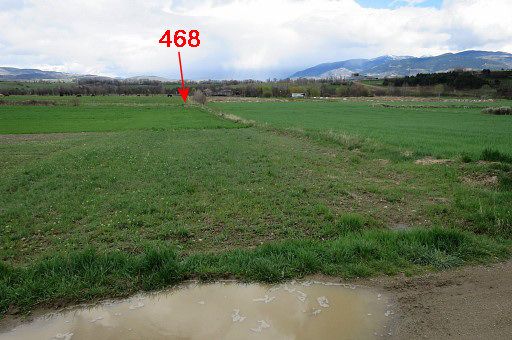 |
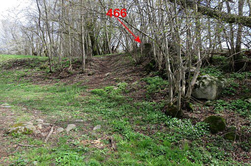
From bm467/2 this view towards bm468. | |||||||||||||||||||||||||||||||||||||||||||||||||||||||||||||||||||||||||||||||||||||||||||||
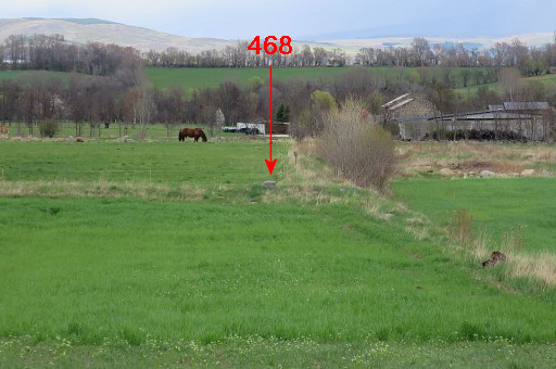 |
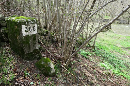
Zoom-in towards bm468. | |||||||||||||||||||||||||||||||||||||||||||||||||||||||||||||||||||||||||||||||||||||||||||||
|
Bm468 Now go NEE along a rough field-edge to |
|||||||||||||||||||||||||||||||||||||||||||||||||||||||||||||||||||||||||||||||||||||||||||||
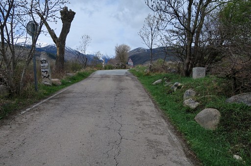
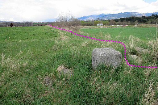
 |
the location of bm469. This map will help you in the last part. |
|||||||||||||||||||||||||||||||||||||||||||||||||||||||||||||||||||||||||||||||||||||||||||||
 |
Bm469 from some distance. |
|||||||||||||||||||||||||||||||||||||||||||||||||||||||||||||||||||||||||||||||||||||||||||||
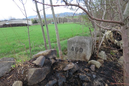 |
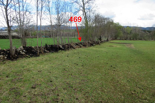
The hedge has suffered from a fire making bm469 more visible. |
|||||||||||||||||||||||||||||||||||||||||||||||||||||||||||||||||||||||||||||||||||||||||||||
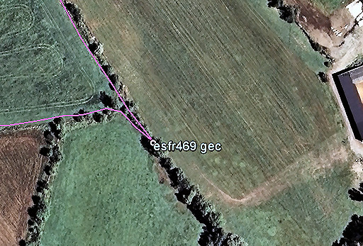
 |
Beyond bm469, follow the field edges as indicated making a detour NNW-NE-SE to keep away from the farm You might have to improvise when field hedges/fences are difficult to cross due to blackberry or cattle (often horses) in the fields. |
|||||||||||||||||||||||||||||||||||||||||||||||||||||||||||||||||||||||||||||||||||||||||||||
 |
You will arrive at this dirtroad. | |||||||||||||||||||||||||||||||||||||||||||||||||||||||||||||||||||||||||||||||||||||||||||||
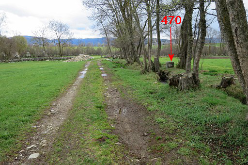 |
Further SE along the dirtroad, bm470 is an easy find. | |||||||||||||||||||||||||||||||||||||||||||||||||||||||||||||||||||||||||||||||||||||||||||||
 |
The next part of this variant. |
|||||||||||||||||||||||||||||||||||||||||||||||||||||||||||||||||||||||||||||||||||||||||||||
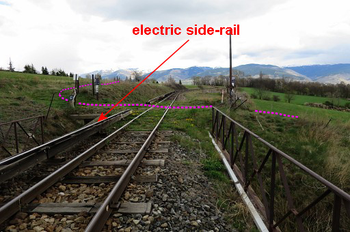 |
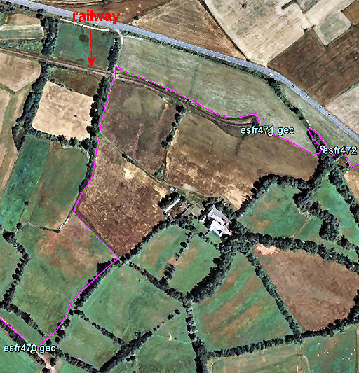
You will cross this railway. |
|||||||||||||||||||||||||||||||||||||||||||||||||||||||||||||||||||||||||||||||||||||||||||||
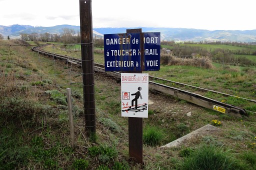 |
Be careful: the 'yellow train' railway-track is dangerous. The side-rail is electric, don't touch it! | |||||||||||||||||||||||||||||||||||||||||||||||||||||||||||||||||||||||||||||||||||||||||||||
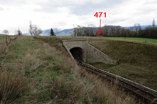 |
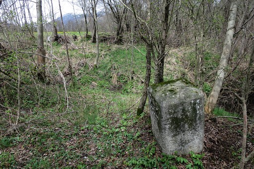
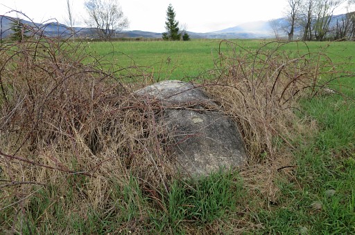
I continue SEE on the N-side of the railway until it dives into a tunnel. The boulder with bm471 can be spotted from here. |
|||||||||||||||||||||||||||||||||||||||||||||||||||||||||||||||||||||||||||||||||||||||||||||
 |
Zoom-in. | |||||||||||||||||||||||||||||||||||||||||||||||||||||||||||||||||||||||||||||||||||||||||||||
 |
Bm471 |
|||||||||||||||||||||||||||||||||||||||||||||||||||||||||||||||||||||||||||||||||||||||||||||
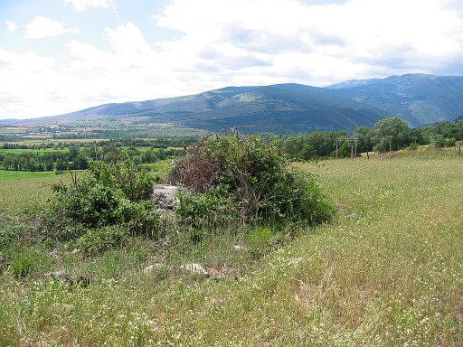 |
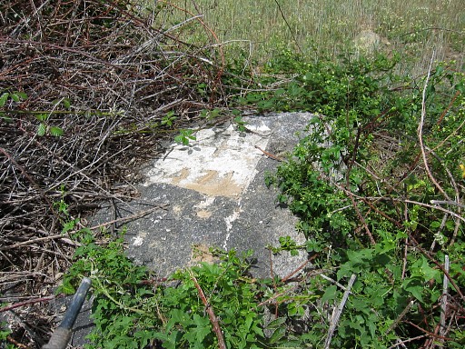
Bm471 is located 35m SE of the tunnel-entrance in this small bush. |
|||||||||||||||||||||||||||||||||||||||||||||||||||||||||||||||||||||||||||||||||||||||||||||
 |
Bm471 |
|||||||||||||||||||||||||||||||||||||||||||||||||||||||||||||||||||||||||||||||||||||||||||||
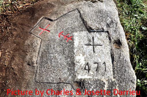 |
In january 2011 I received this picture from Charles & Josette Darrieu. From the documentary on Jean Sermet ("L'homme de la frontière" - Luc Bazin - ArisFilm) they learned that an old cross and arrow were conceiled under the bush. They uncovered the rock and coloured cross and arrow. |
|||||||||||||||||||||||||||||||||||||||||||||||||||||||||||||||||||||||||||||||||||||||||||||
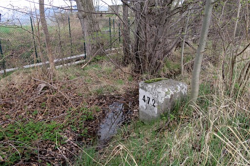 |
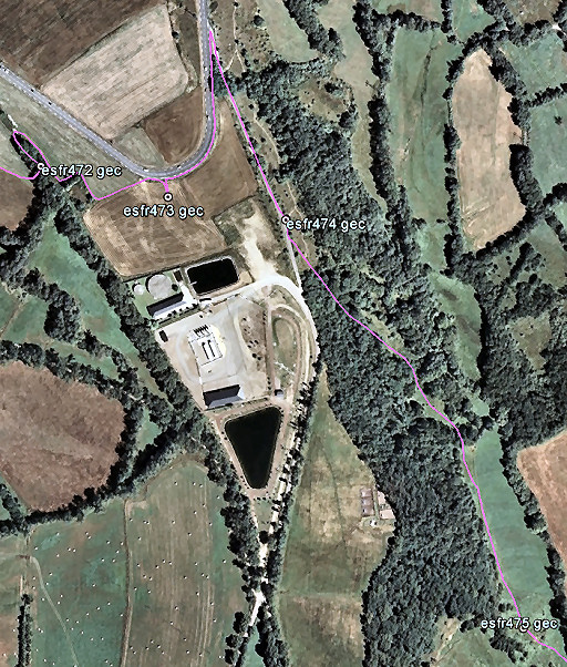
Bm472 is 100m SEE along a small canal/ditch. |
|||||||||||||||||||||||||||||||||||||||||||||||||||||||||||||||||||||||||||||||||||||||||||||
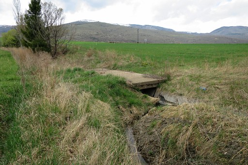 |
A small bridge a bit to the NE lets you enter the adjacent field. | |||||||||||||||||||||||||||||||||||||||||||||||||||||||||||||||||||||||||||||||||||||||||||||
 |
The next part of the variant. |
|||||||||||||||||||||||||||||||||||||||||||||||||||||||||||||||||||||||||||||||||||||||||||||
 |
Bm472 is already visible in the distance near the road. | |||||||||||||||||||||||||||||||||||||||||||||||||||||||||||||||||||||||||||||||||||||||||||||
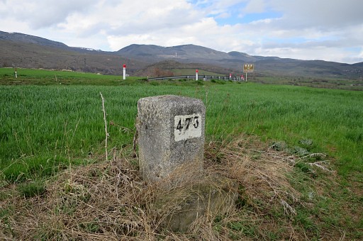 |
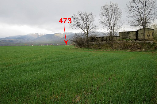
Bm473 Now traverse the field to the road (visible on this picture), follow it NE-N for 200m and take the branch to the right, going S and |
|||||||||||||||||||||||||||||||||||||||||||||||||||||||||||||||||||||||||||||||||||||||||||||
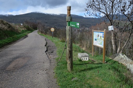 |
walk to bm474 (this picture = looking back). | |||||||||||||||||||||||||||||||||||||||||||||||||||||||||||||||||||||||||||||||||||||||||||||
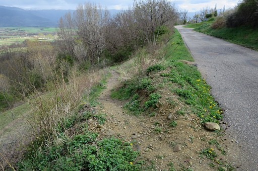 |
Then to bm475. About 20m S from bm474, this trail descends SE |
|||||||||||||||||||||||||||||||||||||||||||||||||||||||||||||||||||||||||||||||||||||||||||||
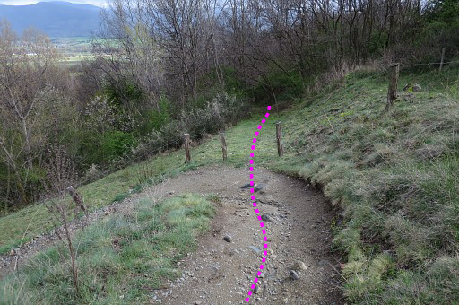 |
At the first bend, enter the field/forest | |||||||||||||||||||||||||||||||||||||||||||||||||||||||||||||||||||||||||||||||||||||||||||||
 |
and descend in the same direction on a kind of trail. The forest opens up after a while and |
|||||||||||||||||||||||||||||||||||||||||||||||||||||||||||||||||||||||||||||||||||||||||||||
 |
you will arrive at meadows like these. Keep the forest at your right hand |
|||||||||||||||||||||||||||||||||||||||||||||||||||||||||||||||||||||||||||||||||||||||||||||
 |
while progressing | |||||||||||||||||||||||||||||||||||||||||||||||||||||||||||||||||||||||||||||||||||||||||||||
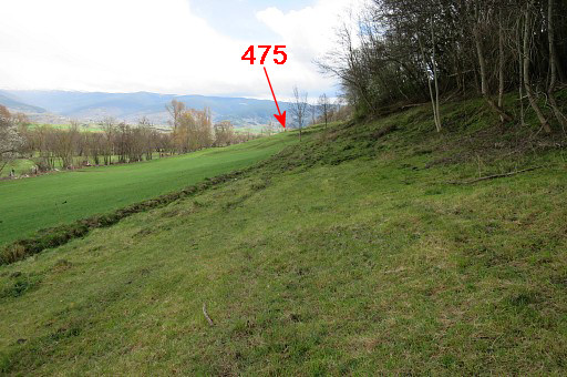 |
and then - in the far distance - bm475 comes in sight. |
|||||||||||||||||||||||||||||||||||||||||||||||||||||||||||||||||||||||||||||||||||||||||||||
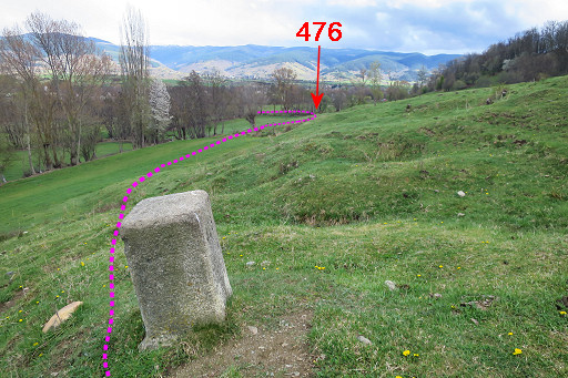 |
Bm475 with your route ahead. |
|||||||||||||||||||||||||||||||||||||||||||||||||||||||||||||||||||||||||||||||||||||||||||||
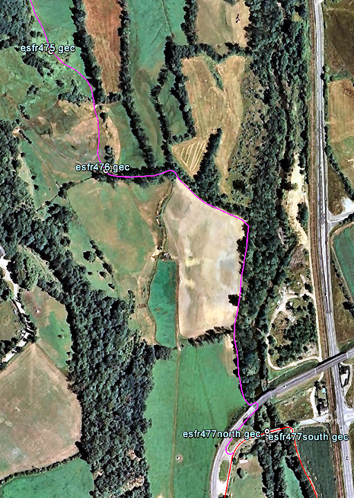 |
From bm475 descend SE and arrive at a dirtroad cq track going S. |
|||||||||||||||||||||||||||||||||||||||||||||||||||||||||||||||||||||||||||||||||||||||||||||
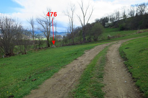 |
A bit further S on that dirtroad, bm476 is in the corner of the meadow. | |||||||||||||||||||||||||||||||||||||||||||||||||||||||||||||||||||||||||||||||||||||||||||||
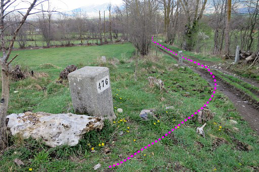 |
Now follow dirtroad and field-edges as indicated at the map above. |
|||||||||||||||||||||||||||||||||||||||||||||||||||||||||||||||||||||||||||||||||||||||||||||
 |
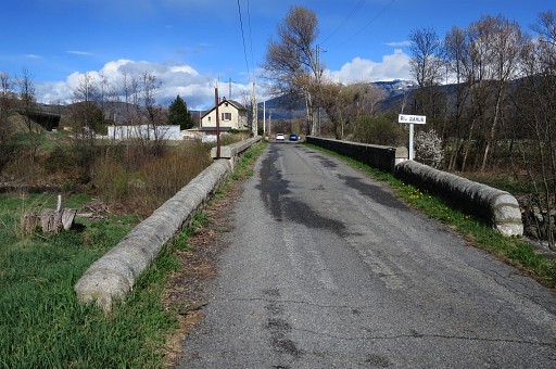
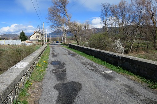
Finally you will arrive at the (new) bridge over the river Rahur. This bridge has its own - unnumbered - bordermarkers on both sides. Parallel to the new bridge is the old bridge where you will join the main route again. |
|||||||||||||||||||||||||||||||||||||||||||||||||||||||||||||||||||||||||||||||||||||||||||||
| End of variant 2 |
||||||||||||||||||||||||||||||||||||||||||||||||||||||||||||||||||||||||||||||||||||||||||||||
 |
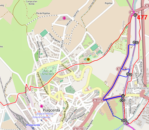
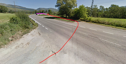
The main route from bm477 to 480 is easy. Cross the old bridge and turn right on a dirtroad. That dirtroad brings you along a camping to a tarmac road entering Bourg-Madame. You will arrive at another bridge (with bm480). (If you intend to include variant 3 (the blue route), you might do bm478es first.) |
|||||||||||||||||||||||||||||||||||||||||||||||||||||||||||||||||||||||||||||||||||||||||||||
 |
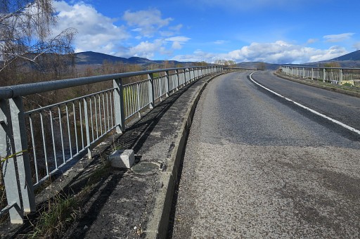
The old bridge with |
|||||||||||||||||||||||||||||||||||||||||||||||||||||||||||||||||||||||||||||||||||||||||||||
 |
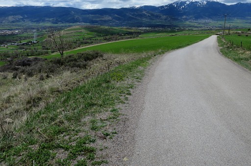
bm477 in the form of two numbers engraved and painted on both balustrades. Just beyond the bridge, turn right and continue S on a dirtroad. |
|||||||||||||||||||||||||||||||||||||||||||||||||||||||||||||||||||||||||||||||||||||||||||||
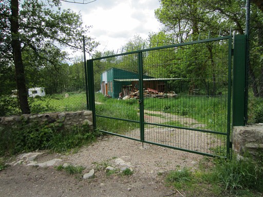 |
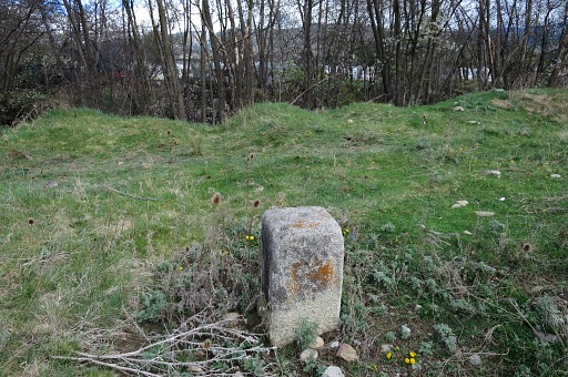
After 400m you will arrive at this gate at your right hand. Bm480fr is inaccessible in this high-fenced meadow annex caravan storage. But you can spot the bm through the fence. |
|||||||||||||||||||||||||||||||||||||||||||||||||||||||||||||||||||||||||||||||||||||||||||||
 |
However: from the backside (= riverside) of the terrain, the bordermarker is better visible. The number is only visible from this side. This picture: taken through the fence. |
|||||||||||||||||||||||||||||||||||||||||||||||||||||||||||||||||||||||||||||||||||||||||||||
 |
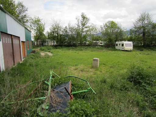
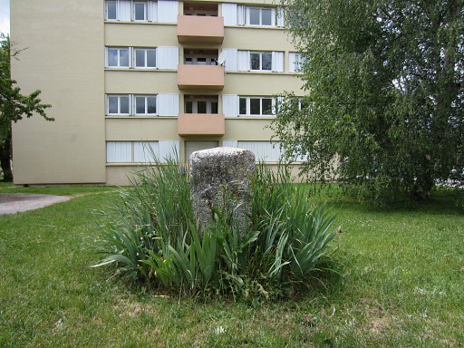
Further
on, having entered the village of Bourg-Madame, bm497fr is located to
the right in a private garden of a children's home. This picture: taken through the fence. |
|||||||||||||||||||||||||||||||||||||||||||||||||||||||||||||||||||||||||||||||||||||||||||||
 |
Then
arriving at the bridge = border between Puigcerda and Bourg-Madame.
Bm480 consists of two stone markers on each side of the bridge. Variant 3 starts from here and goes straight ahead into Spain. |
|||||||||||||||||||||||||||||||||||||||||||||||||||||||||||||||||||||||||||||||||||||||||||||
| Variant 3 via bm479es, 478es, 482es and 481es | ||||||||||||||||||||||||||||||||||||||||||||||||||||||||||||||||||||||||||||||||||||||||||||||
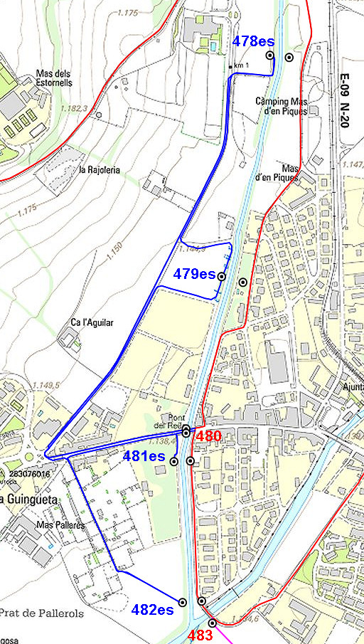 |
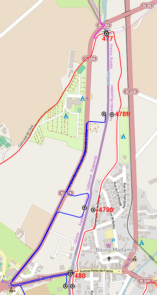
Covering the four bordermarkers on the Spanish side of the river Rahur requires going hence and forth several times. It also involves in all four cases entering private fields or garden. Walk first - from the bridge with the double bm480 - to the roundabout and turn right on the N154, The map shows where to leave the road to access both bm479es and 478es. |
|||||||||||||||||||||||||||||||||||||||||||||||||||||||||||||||||||||||||||||||||||||||||||||
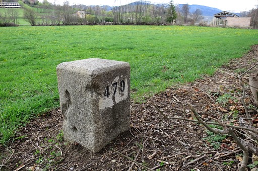 |
Bm479es |
|||||||||||||||||||||||||||||||||||||||||||||||||||||||||||||||||||||||||||||||||||||||||||||
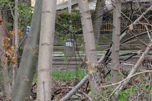 |
This picture: from bm479es looking towards the river with on the other side the children's home with bm479fr visible. | |||||||||||||||||||||||||||||||||||||||||||||||||||||||||||||||||||||||||||||||||||||||||||||
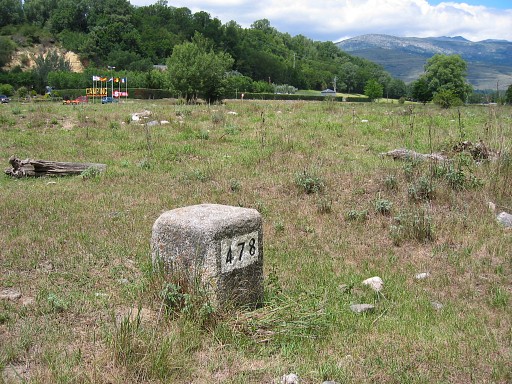 |
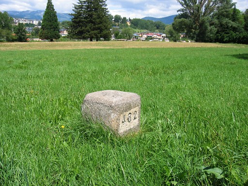
Bm478es with camping Stel in the background. | |||||||||||||||||||||||||||||||||||||||||||||||||||||||||||||||||||||||||||||||||||||||||||||
 |
Bm478es, looking towards the river with at the other side glimpses of the caravans where twinbrother bm478fr is located. | |||||||||||||||||||||||||||||||||||||||||||||||||||||||||||||||||||||||||||||||||||||||||||||
|
Now return to the roundabout and then take a dirtroad as shown on the map. On either side of this dirtroad are small vegetable gardens. |
|||||||||||||||||||||||||||||||||||||||||||||||||||||||||||||||||||||||||||||||||||||||||||||
| The dirtraod ends at this meadow. You can spot bm482es in the distance |
||||||||||||||||||||||||||||||||||||||||||||||||||||||||||||||||||||||||||||||||||||||||||||||
| Zoom-in | ||||||||||||||||||||||||||||||||||||||||||||||||||||||||||||||||||||||||||||||||||||||||||||||
 |
It's a short walk (150m) hence and forth through the meadow to bm482es. Then return via the roundabout to the bridge with bm480. |
|||||||||||||||||||||||||||||||||||||||||||||||||||||||||||||||||||||||||||||||||||||||||||||
 |
Back at the bridge. To cover bm481es, take a small trail to the right between river and fence as indicated on this picture. |
|||||||||||||||||||||||||||||||||||||||||||||||||||||||||||||||||||||||||||||||||||||||||||||
 |
The fence beomes a wall and you will - after ± 50m - arive at this point. Here you can climb easily over the wall. Now tresspassing becomes serious. Bm481es is on the other side of the wall in the private garden of a - since long - deserted villa. But it may be inhabited or guarded when you visit the site. So you'd better check first at the street side and ask permission when possible. |
|||||||||||||||||||||||||||||||||||||||||||||||||||||||||||||||||||||||||||||||||||||||||||||
 |
When you have climbed over the
wall, go left along the wall for 10-20m. Bm481es is hidden in a bush ± 1m from the wall. You have to enter the bush to spot it. It gets more overgrown every year. Return the same way, back to the bridge. |
|||||||||||||||||||||||||||||||||||||||||||||||||||||||||||||||||||||||||||||||||||||||||||||
| End of variant 2 |
||||||||||||||||||||||||||||||||||||||||||||||||||||||||||||||||||||||||||||||||||||||||||||||
 |
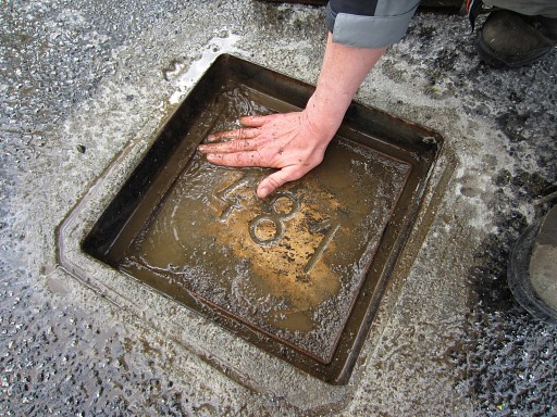
You are back on the main route, ready to continue with the bm481fr- and bm482fr-markers. However: the original markers have been replaced by metal plaques in the surface of the road. Apparently done when the road was constructed. |
|||||||||||||||||||||||||||||||||||||||||||||||||||||||||||||||||||||||||||||||||||||||||||||
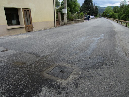 |
Bm481fr had difficulties surviving the new tarmac surface. It has got finally a steel cover which can be lifted with a rope. |
|||||||||||||||||||||||||||||||||||||||||||||||||||||||||||||||||||||||||||||||||||||||||||||
 |
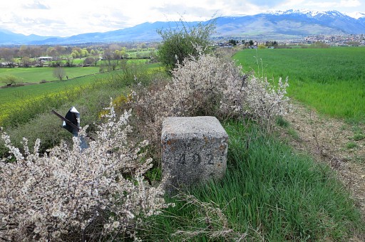
Bm491fr |
|||||||||||||||||||||||||||||||||||||||||||||||||||||||||||||||||||||||||||||||||||||||||||||
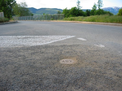 |
Further on, bm482fr still in good shape. |
|||||||||||||||||||||||||||||||||||||||||||||||||||||||||||||||||||||||||||||||||||||||||||||
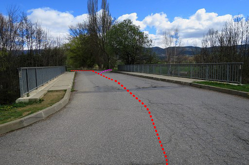 |
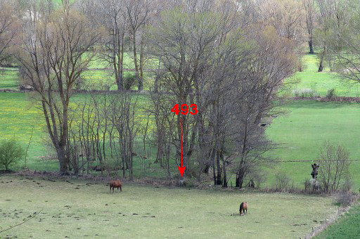
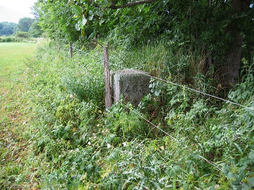
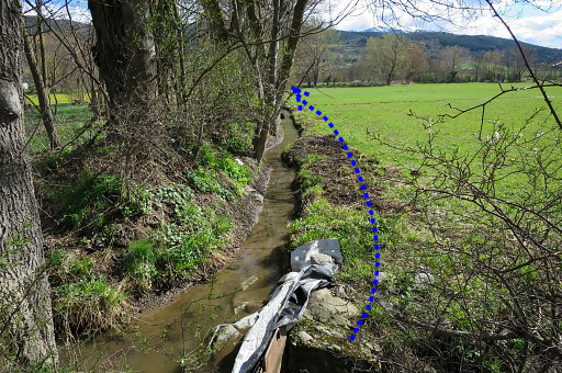
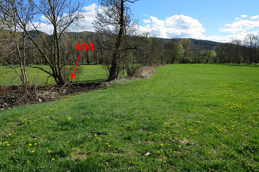
This is the bridge just NW of bm483. Coming from bm482fr, you have to cross the bridge. The main route of the GRPdesBf |
|||||||||||||||||||||||||||||||||||||||||||||||||||||||||||||||||||||||||||||||||||||||||||||
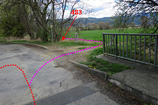 |
then turns left. Variant 4 along bm484-495 starts to the right but bm483 belongs formally to the main route because it's within a 100m reach of it. |
|||||||||||||||||||||||||||||||||||||||||||||||||||||||||||||||||||||||||||||||||||||||||||||
 |
Bm483 is just 'around the corner'. | |||||||||||||||||||||||||||||||||||||||||||||||||||||||||||||||||||||||||||||||||||||||||||||
|
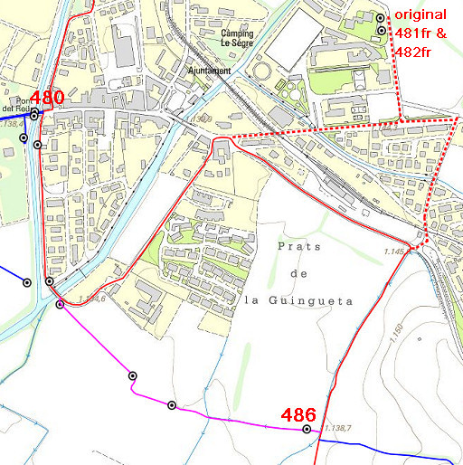
The main route now makes a detour on public roads to bm486, well visible on this map. I you want to visit to original bm481fr and 482fr, follow the dotted route (800m extra). The original markers are being stored at the premises of an apartment-building, named "Cité des Douanes' in the Rue des Narcissus. This map shows where that building is and it's an easy detour from the main route. |
|||||||||||||||||||||||||||||||||||||||||||||||||||||||||||||||||||||||||||||||||||||||||||||
 |
This is the old bm481fr | |||||||||||||||||||||||||||||||||||||||||||||||||||||||||||||||||||||||||||||||||||||||||||||
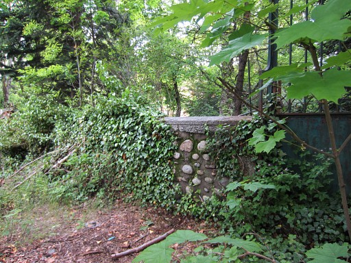
 |
And this is the old bm482fr, standing in front of the apartment-building. |
|||||||||||||||||||||||||||||||||||||||||||||||||||||||||||||||||||||||||||||||||||||||||||||
| Variant 4 via bm484-485 | ||||||||||||||||||||||||||||||||||||||||||||||||||||||||||||||||||||||||||||||||||||||||||||||
 |
||||||||||||||||||||||||||||||||||||||||||||||||||||||||||||||||||||||||||||||||||||||||||||||
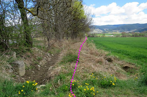
|
From bm483, navigation is easy along the field-edges. |
|||||||||||||||||||||||||||||||||||||||||||||||||||||||||||||||||||||||||||||||||||||||||||||
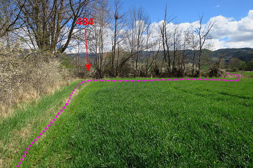 |
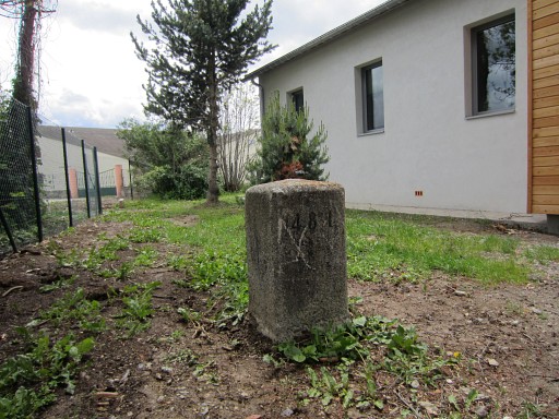
At the end of the first field, bm484 is in the corner but behind the hedge. | |||||||||||||||||||||||||||||||||||||||||||||||||||||||||||||||||||||||||||||||||||||||||||||
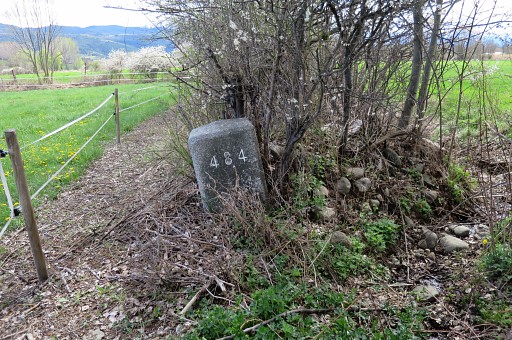 |
Bm484 might be hidden in summertime but its spot is very clear. |
|||||||||||||||||||||||||||||||||||||||||||||||||||||||||||||||||||||||||||||||||||||||||||||
 |
Further on, passing along bm485. |
|||||||||||||||||||||||||||||||||||||||||||||||||||||||||||||||||||||||||||||||||||||||||||||
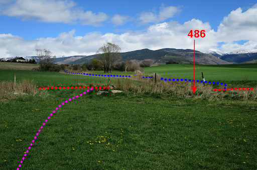 |
And - at the end of the meadow - ariving at the dirtroad where the main route passes. From this stand of view, bm486 is hidden in the ditch. |
|||||||||||||||||||||||||||||||||||||||||||||||||||||||||||||||||||||||||||||||||||||||||||||
| End of variant 4 |
||||||||||||||||||||||||||||||||||||||||||||||||||||||||||||||||||||||||||||||||||||||||||||||
 |
Bm486. The mains route continues on this dirtroad to the village of Age. |
|||||||||||||||||||||||||||||||||||||||||||||||||||||||||||||||||||||||||||||||||||||||||||||
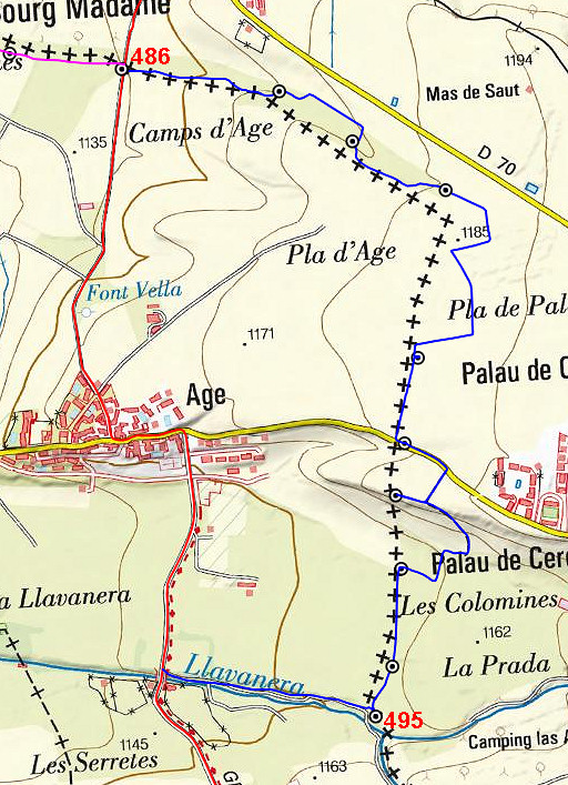 |
The main route - until its junction again with variant 5 - is easy to find. |
|||||||||||||||||||||||||||||||||||||||||||||||||||||||||||||||||||||||||||||||||||||||||||||
| Variant 5 via bm487-494 | ||||||||||||||||||||||||||||||||||||||||||||||||||||||||||||||||||||||||||||||||||||||||||||||
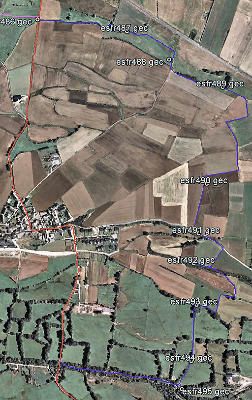 |
Variant 5 is another 'dive' into the fields. Again: directions are less helpful, use the maps hereunder to navigate. |
|||||||||||||||||||||||||||||||||||||||||||||||||||||||||||||||||||||||||||||||||||||||||||||
 |
||||||||||||||||||||||||||||||||||||||||||||||||||||||||||||||||||||||||||||||||||||||||||||||
|
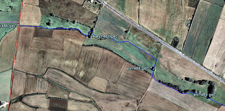
First from bm486 to 487 which can
be done best by taking a track on the spanish side of the border (the blue line on this picture). Then (after 100m) enter a French meadow, still going E. |
|||||||||||||||||||||||||||||||||||||||||||||||||||||||||||||||||||||||||||||||||||||||||||||
 |
Traverse the meadow to the E, arriving at this 'gate'. From here you can already spot the spot of bm487. |
|||||||||||||||||||||||||||||||||||||||||||||||||||||||||||||||||||||||||||||||||||||||||||||
 |
Zoom-in to bm487 | |||||||||||||||||||||||||||||||||||||||||||||||||||||||||||||||||||||||||||||||||||||||||||||
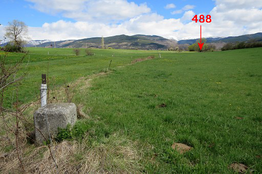 |
Bm487 You can spot bm488 already from here. |
|||||||||||||||||||||||||||||||||||||||||||||||||||||||||||||||||||||||||||||||||||||||||||||
 |
zoom-in to bm488 | |||||||||||||||||||||||||||||||||||||||||||||||||||||||||||||||||||||||||||||||||||||||||||||
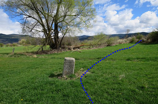 |
Bm488 From bm488 switch to the spanish side via a 'corridor' in the hedge. |
|||||||||||||||||||||||||||||||||||||||||||||||||||||||||||||||||||||||||||||||||||||||||||||
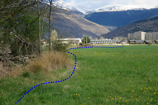
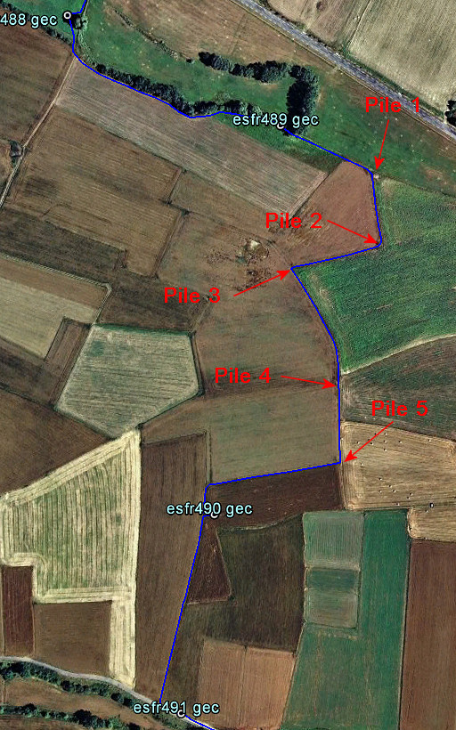 |
The next part of this variant. The 5 piles of stones will help you to navigate from bm489 to 490. |
|||||||||||||||||||||||||||||||||||||||||||||||||||||||||||||||||||||||||||||||||||||||||||||
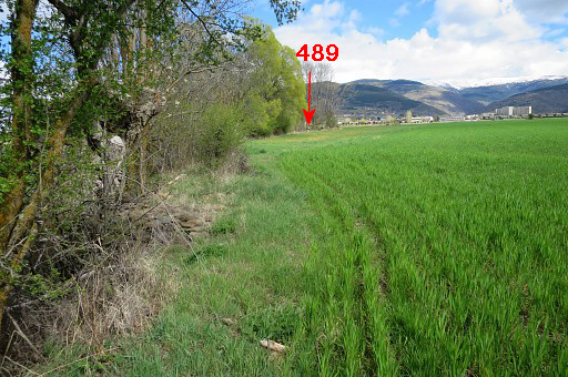 |
But first - from the 'corridor' in the hedge - continue E along the field-edge and soon you will spot in the distance | |||||||||||||||||||||||||||||||||||||||||||||||||||||||||||||||||||||||||||||||||||||||||||||
 |
bm489. If the fields are empty with crops, you might head directly S for ±500m to bm490 which should be - in the case of empty fields - visible from far distance. But probably you have to follow the field-edges as this map shows to protect the crops. Luckily some stone-piles (see pictures) help you to navigate. |
|||||||||||||||||||||||||||||||||||||||||||||||||||||||||||||||||||||||||||||||||||||||||||||
 |
This picture: from bm489 looking SEE to the first of them. | |||||||||||||||||||||||||||||||||||||||||||||||||||||||||||||||||||||||||||||||||||||||||||||
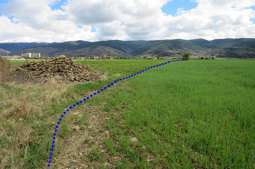 |
The first pile of stones with in the distance the second pile. | |||||||||||||||||||||||||||||||||||||||||||||||||||||||||||||||||||||||||||||||||||||||||||||
 |
This is the second pile, looking forward to |
|||||||||||||||||||||||||||||||||||||||||||||||||||||||||||||||||||||||||||||||||||||||||||||
 |
a third one but a lot smaller. At the third pile, go left. | |||||||||||||||||||||||||||||||||||||||||||||||||||||||||||||||||||||||||||||||||||||||||||||
 |
The third pile and looking in the direction to go. The field edge curves to the right in the distance and arrives |
|||||||||||||||||||||||||||||||||||||||||||||||||||||||||||||||||||||||||||||||||||||||||||||
 |
at this fourth pile of stones. Ahead is the last |
|||||||||||||||||||||||||||||||||||||||||||||||||||||||||||||||||||||||||||||||||||||||||||||
 |
small pile of stones. | |||||||||||||||||||||||||||||||||||||||||||||||||||||||||||||||||||||||||||||||||||||||||||||
 |
At this fifth pile, turn right and walk 150m to the W between two fields until the end of the left field. Then turn left for the last 30m to bm490. |
|||||||||||||||||||||||||||||||||||||||||||||||||||||||||||||||||||||||||||||||||||||||||||||
 |
But bm490 can probably already be spotted to the left | |||||||||||||||||||||||||||||||||||||||||||||||||||||||||||||||||||||||||||||||||||||||||||||
 |
Bm490 From bm490 head SSW along the field-edge (as indicated) to |
|||||||||||||||||||||||||||||||||||||||||||||||||||||||||||||||||||||||||||||||||||||||||||||
 |
the road with bm491 a bit to the left. |
|||||||||||||||||||||||||||||||||||||||||||||||||||||||||||||||||||||||||||||||||||||||||||||
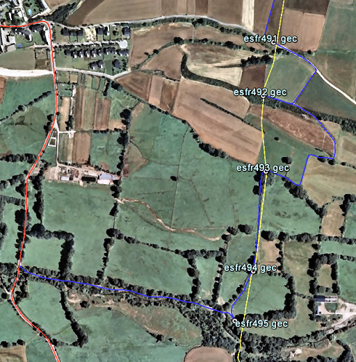 |
The last part of this variant. From bm491 proceed E for 125m on the dirtroad and then take a dirtroad to the right. |
|||||||||||||||||||||||||||||||||||||||||||||||||||||||||||||||||||||||||||||||||||||||||||||
 |
To reach bm492, go hence & forth along the field edge as indicated on the map above. |
|||||||||||||||||||||||||||||||||||||||||||||||||||||||||||||||||||||||||||||||||||||||||||||
 |
Bm492, looking forward to the spot of bm493. A direct traverse to bm493 is not possible because of a impenetrable strip of undergrowth. So you have to return to the dirtroad and descend to the meadows. |
|||||||||||||||||||||||||||||||||||||||||||||||||||||||||||||||||||||||||||||||||||||||||||||
 |
Zoom-in to bm493. |
|||||||||||||||||||||||||||||||||||||||||||||||||||||||||||||||||||||||||||||||||||||||||||||
 |
Via the meadows, you can reach bm493. |
|||||||||||||||||||||||||||||||||||||||||||||||||||||||||||||||||||||||||||||||||||||||||||||
 |
Then proceed S along the field-edge (W-side) | |||||||||||||||||||||||||||||||||||||||||||||||||||||||||||||||||||||||||||||||||||||||||||||
 |
to bm494 which is here. | |||||||||||||||||||||||||||||||||||||||||||||||||||||||||||||||||||||||||||||||||||||||||||||
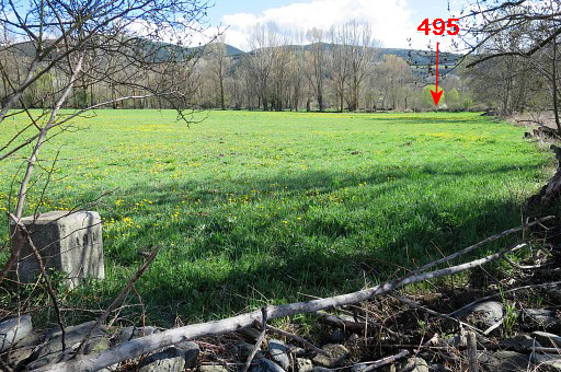 |
From here bm495 is already visible S at the other end of the meadow. | |||||||||||||||||||||||||||||||||||||||||||||||||||||||||||||||||||||||||||||||||||||||||||||
 |
Zoom-in to bm495 | |||||||||||||||||||||||||||||||||||||||||||||||||||||||||||||||||||||||||||||||||||||||||||||
 |
Bm495 The meadow exit is closeby. |
|||||||||||||||||||||||||||||||||||||||||||||||||||||||||||||||||||||||||||||||||||||||||||||
 |
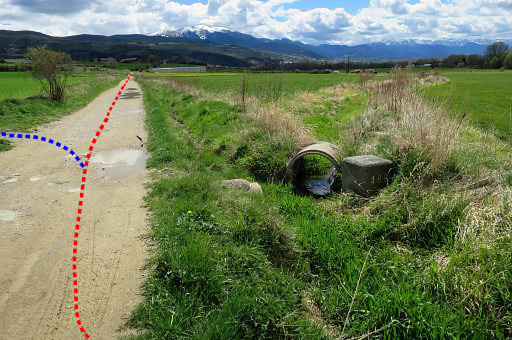
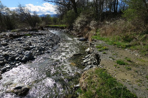
This is the exit of the meadow, looking W to the dirtroad leading to the bridge. |
|||||||||||||||||||||||||||||||||||||||||||||||||||||||||||||||||||||||||||||||||||||||||||||
 |
Now go W on that dirtroad which partly has vanished by floodings. |
|||||||||||||||||||||||||||||||||||||||||||||||||||||||||||||||||||||||||||||||||||||||||||||
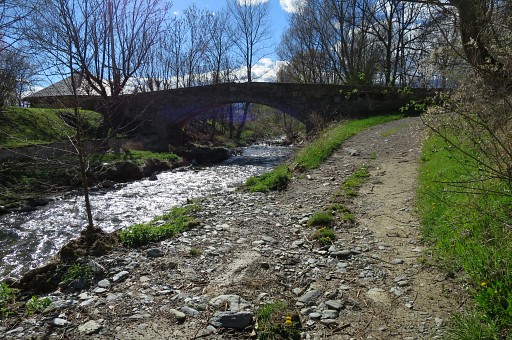 |
Arriving at the bridge and the tarmac road. Then you're back at the main route. Go left at the bridge. |
|||||||||||||||||||||||||||||||||||||||||||||||||||||||||||||||||||||||||||||||||||||||||||||
| End of variant 5 |
||||||||||||||||||||||||||||||||||||||||||||||||||||||||||||||||||||||||||||||||||||||||||||||
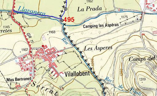 |
The last part of this stage: an easy 650m to reach the village of Vilallovent. Note the camping-site nearby in France. |
|||||||||||||||||||||||||||||||||||||||||||||||||||||||||||||||||||||||||||||||||||||||||||||