|
The
bordermarkers of the Pyrenees : bornes de paçage Luchon-Aran
 |
|
next page |
 |
|
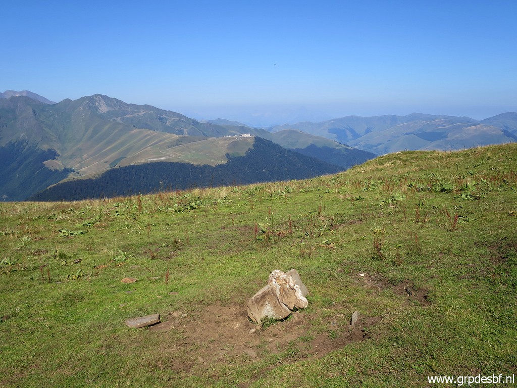
The main focus of my project are the numbered esfr-bordermarkers, fitting in the 1-602 sequence. But
there are more markers along the esfr-border.
|
|
 |
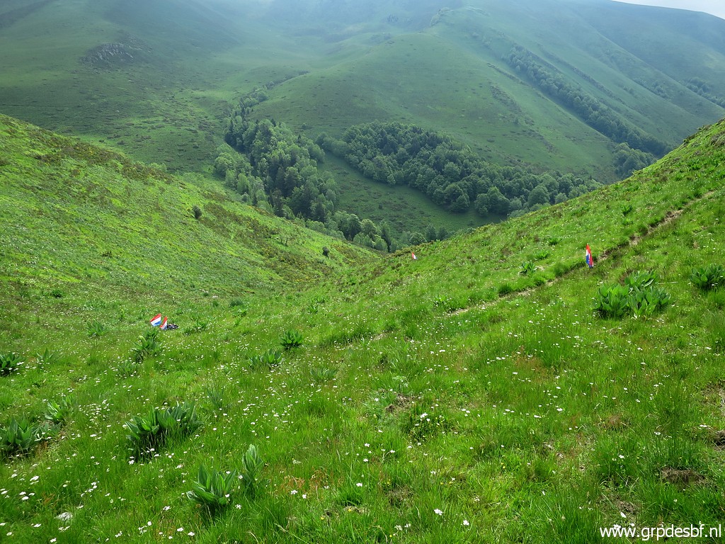
In this case: the 28 small markers
which were placed in the 1860-ies and reinstalled in the 1950-ies to
demarcate Spanish grazing grounds on French territory, south of Bagnères-de-Luchon. In august 2018, I searched for the still existing markers (19) with the gps-waypoints provided by Charles & Josette Darrieu & Paco Nudels. I found them all. But what is their history? And where are the missing 9 bornes? Update: in april 2021, I got additional documentation from Charles Darrieu. In june 2021 I searched in vain for the missing markers S, T, U & X. |
| Sources * Convention additionnelle au Traité de délimitation du 14 avril 1862, signée à Bayonne" p.70-74: "Abornement des terrains dont diverses municipalités Aranaises sont en possession en France dans la circonscription de la commune de Bagnères-de-Luchon. Éclaircissements prescrits par l'article 18 du Traité et autres dispositions nécessaires" -> download pdf-file. This pdf as a whole is the treaty-annex which describes the actual localisation of the bordermarkers 273-426. * The part concerning the bornes de paçages (p.70-74) has been translated in English and summarized and restructured by me -> download pdf * Les paçages attribués en France dans la Haute Vallée de la Pique Luchonnaise aux Espagnols du Val d'Aran" / Jean Sermet Revue Pyrénées, N°130 1982, p. 123-151 -> download pdf, its source = gallica.bnf.fr / Bibliothèque nationale de France, see also this page. (part 1 of a detailed article on the history of these markers and on their reinstallment around 1960, Jean Sermet was in charge of the French delegation. Sermet's articles give an erudite and vivid account of all the negotiations and considerations and decisions) * Les paçages attribués en France dans la Haute Vallée de la Pique Luchonnaise aux Espagnols du Val d'Aran (suite) / Jean Sermet Revue Pyrénées, N°131 1982, p. 231-251 -> download pdf, its source= gallica.bnf.fr / Bibliothèque nationale de Francethe, see also this page. (part 2 of a detailed article on the history of these markers and on their reinstallment around 1960, Jean Sermet was in charge of the French delegation. Sermet's articles give an erudite and vivid account of all the negotiations and considerations and decisions) * The waypoints of the remaining bornes de paçage by Charles & Josette Darrieu and Paco Nudels. They did their searches in 2007-2009. Probably, they were the first and only trying to find them in the past. They found 19 markers from the 28 which were reinstalled around 1960. I consider that as a tremendous achievement on this tough terrain and with so few clues. Several of them were totally overgrown by grass. I found all 19 thanks to their waypoints and these waypoints have been added to esfr-bordermarkers-all-waypoints.kml (and esfr-bordermarkers-all-waypoints.gpx). I also added the probable spots of the missing bornes de paçages. Update 2021: I adjusted the supposed locations of the missing markers with the help of a recently acquired map of Jean Sermet. See hereunder. * Webpage of Paco Nudels, showing nice pictures of the still existing markers in 2007-2009 (but not all) including some reference engravings on rocks nearby. Added sources in 2021: |
|
| *
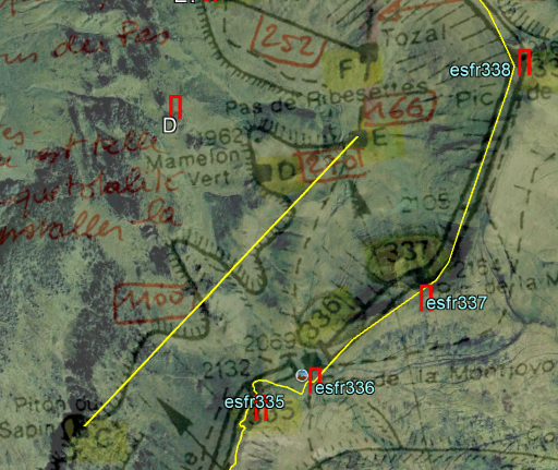
A map of the area with the borders of the pacages and the locations of
the 'bornes de pacage', provided by Charles Darrieu with his own
handwritten annotations. According to Charles an appendix to the book
of Jean Sermet: "La Frontière des Pyrénées" while his annotations are
derived from Sermet's articles "1957-1959 - Pâturages espagnols en
Haute-Garonne" and "1960 - Abornement Haute-Garonne-Journal des
opérations 1960". See the map on full scale with this link. Probably this map was an intermediate draft because we notice in Sermet's articles some deviations, e.g. concerning marker X which was ultimately placed more to the SE. |
 |
 |
I tried to calibrate
this map in Google Earth which worked quite well for the natural
features like the borderridge and lakes and trails. It gives also new information on the spots of the missing 'bornes de pacages' and the borderlines of the 'pacages'. But I must conclude that the locations of the markers must be considered as approximative because a lot of the spots of the already found 'bornes de pacage' (2018) don't match well with the locations on the calibrated map. But for some of the missing markers, the indication of trails of ridges at the map sure helps for a better positioning. To download the GE-overlay, use this link. |
| * a gpx-file provided by Charles Darrieu
with his own estimation of the supposed spots of the missing 9 markers
(and the found ones). A missing marker contains a 's' behind it
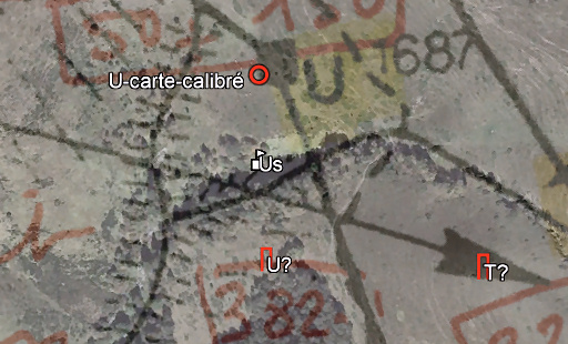
(= "supposé"), e.g. Ts for the missing marker T. Summarizing: we have for each missing marker 3 possible estimated locations which are assembled in this gpx-file: one by Charles Darrieu (e.g. Ts), one by me as reasoned in 2018 (e.g. T?) and one based on the calibrated Sermet-map (e.g. T-carte-calibré). My latest estimations of the spots of the missing markers (based on the Sermet-map and description in his articles have been incorporated in the overall esfr-bordermarkers-all-waypoints.kml (and esfr-bordermarkers-all-waypoints.gpx) files. |
|
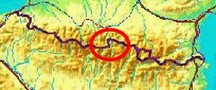
| The 'bornes de paçages' Luchon-Aran in the 1860-ies In the middle of the 19th century the French-Spanish border was precisely demarcated by more than 600 bordermarkers and - crosses which was described in several treaties. But that was not all: in many cases local crossborder agreements on grazing access were included and in some case local markers to demarcate grazing grounds of communities from the other side of the border. That was also the case in the area south of Bagnères-de-Luchon. The terrain involved is the upper valley between Col de Barèges (bm356) to the south to Pas de l'Escalette (bm333) and well the west-hillside of the borderridge. 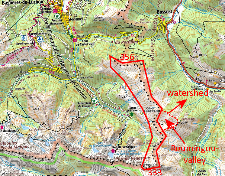 The course of the international border left no doubt: it was the mountain ridge separating this valley with the Aran-valley. This dates back to the fourteenth century when the Val d'Aran was assigned to the Kingdom of Aragon. On the other side of the ridge applies the Charter of 1315 by the Compte de Comminges in which he granted the unique usage to Bagnères-de-Luchon of the "vallée de la Pique" up to the highest ridges. In the treaty of 1862 however, it was stipulated that the 'montagne de la Pouylané", that is the valley of Roumingou on the French side of the watershed was (to remain) Spanish territory. So far so good. But there was a large problem: since ages the French versant was being used by the Spanish communities at the other side for cattle grazing, grazing grounds being scarce on their side. And they considered these pastures 'de facto' as their property. It led in the 19th century with its growing pressure on resources due to the population growth, to many conflicts with French shepherds. The bordercommission decided that - along with the placements of the international markers - these rights of possession had to be regulated by demarcating the various pastures of the various communities. However, there was no document whatsoever supporting the claims of the Spanish, let alone giving indications of their boundaries. General Callier, the head of the French bordercommission for many years found the delimitation of the grazing grounds very difficult. In order to reach a satisfactory result for all parties, a long proces of investigating and negotiating was needed in which the attitude of the Spanish parties was labeled by Callier as being temperamentful. Finally an agreement was reached and 27 small markers and one cross were being placed/engraved. But they all disappeared within a few years (except for the cross), the same fate as which fell upon the international masonry markers on the borderridge. The limits of the 'paçages' on a map Note: the limits on this map are drawn based on the existing markers (rebuilt in 1959-1960), an estimation of the positions of the missing markers and close reading of the treaty-text. Roughly these limits are the same - I think - as in 1862. You can download a kml-file (Google Earth) with these limits (+ existing & missing markers and the relevant international markers).  Update august 2021:
the recently acquired map of Jean Sermet (mentioned above in de
Sources-section, see this map on full scale with this link), show partly different borderlines, especially in the
most southern 'pacage' of Aubert, including a much different position
of the markers D, E, F and G. Update august 2021:
the recently acquired map of Jean Sermet (mentioned above in de
Sources-section, see this map on full scale with this link), show partly different borderlines, especially in the
most southern 'pacage' of Aubert, including a much different position
of the markers D, E, F and G. The Pas de Ribesettes turns out to be at a completely other position than I figured. Has yet to be worked out on my own map hereunder. 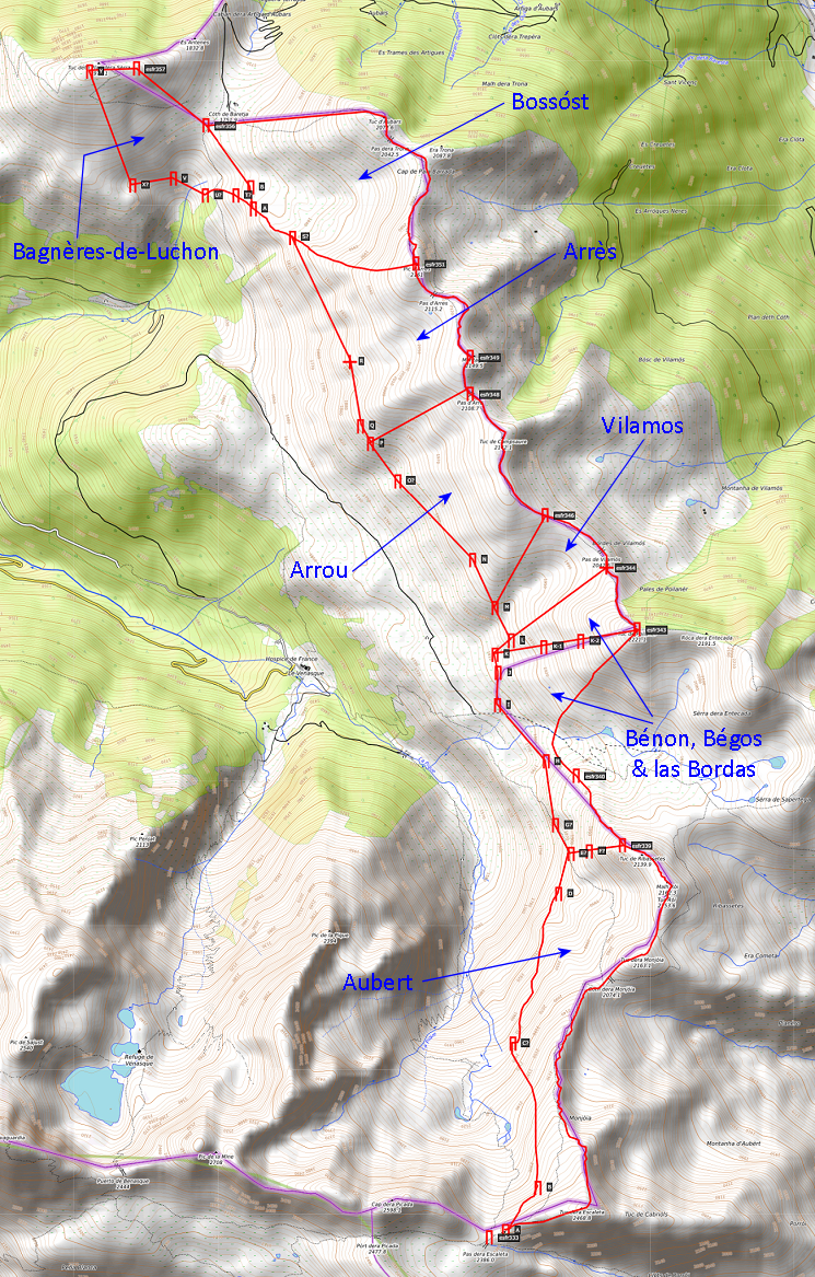 This map can be viewed on a larger scale on this page. Update 2021: the changes as discussed above have yet to be incorporated in this map. |
|
The restauration in the 1950-ies After WWII France and Spain decided to reinstall all bordermarkers which had disappeared. That was a large project in the Haute Garonne area where all bordermarkers (with some exceptions, mostly bordercrosses) were gone. The work was executed in the 1950-ies. A new type of bordermarker was engineered, easy to transport & build and made to last. Nowadays - after 70 years - they all still exist. But the 'bornes de paçages' of 1862 had also disappeared and the bordercommission decided to reinstall them as well. Why, one might ask. They were gone soon after their construction around 1860 and since then no one really cared, so it seems. And once intensely used for grazing cattle, the versants in question seemed almost deserted in the 1950-ies. But still in 1953 there had been a fierce dispute between Bossost and Bagnères-de-Luchon as was the case regularly in earlier decades. That's why the commission decided to replace them as a separate project. Localization and negotiating Localization of the original spots was not an easy task. Neither was achieving the agreement of the various communties. The treaty of 1862 gave directions and in-between-distances for the markers to be placed but this was however often not precise enough for an exact relocation. All markers had already disappeared a few years after their placement, thus offering no reference. There were two exceptions: 1. marker R which was the only one which was engraved on a rock was found back, 2. earlier in 1957 the concrete base of K was found back, next to a rock with an ancient engraving. Moreover in 1960 the discovery of a rock with ancient engravings along the ruisseau des Berns allowed to determine the position of marker V. All other marker-locations had to be established again by close reading of the Treaty, new distance measurements and questioning the parties concerned. But there was another problem. As in the 19th century, the Spanish shepherds were tough negotiators trying to extend their grazing limits presenting various reasons and proofs, sometimes unreasonnable and unreliable, or by holding back information. At one time an old shepherd of 85 years was brought to the scene to show some forgotten cross on some rock proving some claim on an extension of their possessions. At one point the surveyor's 100m cord was grabbed from the hands of the surveyor, only to be recovered by mediation of a local official. The bordercommission was sometimes mild on the demands of the Spanish resulting in a replacement giving them more space then the Treaty seemed to prescribe. But they also couldn't avoid disappointment when claims could not be fitted at all in the Treaty-indications. This was especially the case with the Bossost-shepherds who were furious when the commission forced them to accept the common use ('compascuité') of their pastures by the Bagnères-de-Luchon-shepherds as explicitly mentioned in the treaty. But in general Sermet himself could understand the inclination of the Spanish to extend their claims downhill to more grass and better access to water as the natural inclination of their cattle was. Perhaps - he pondered - the commission of the 1860-ies had been too rigid. Anyway, the commission of the 1950-ies was mild on their demands and facilitating access to water downhill whenever possible and reasonably fitting in the treaty. Fabrication and transport |
|
 |
The
markers were constructed in 1958 in France according to the dimensions
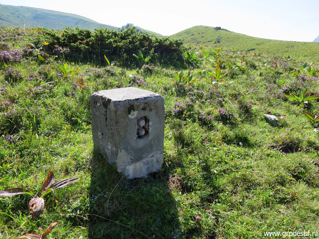
of the treaty. Dimensions: 30x30cm and a height of 70cm in order to bury 30cm underground. At a weight of 160 kilo they would be difficult to transport (with mules, which was to be payed/done by Spain) and therefore made in two halves to be joined at the spot. |
 |
The
prism-shape of the top had to be added after they were planted,
apparently by cement. There is only one of the still existing markers which shows that prism-top: marker A. |
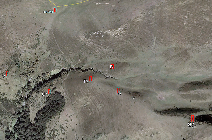
| The installation of the markers The markers were placed in july 1959. But localisation of the markers V and Y was uncertain, not finding the reference rocks mentioned in the treaty. Still they were placed on provisory spots but that needed a new examination. That problem was solved in july 1960 when luckily the spot of the rock near V was revealed by a shepherd. Also the markers A & B - with T forming the west border of Coume d'Arrès - remained subject of doubts. That led in 1967 to another location for B. The actual markers: found and not found In august 2018 I searched for the still existing markers found 10 years earlier by Charles & Josette Darrieu and Paco Nudels. I did find them all but didn't look for the other - missing - markers, not yet having established their approximate coordinates. Update: in june 2021 I searched in vain for the missing markers S, T, U & X. That search was a tiring and partly frustrating job and confirmed what Charles Darrieu wrote to me: "Searching an area systematically is tiring and discouragement arrives soon because one doesn't know if the marker is still in place or if it has been destroyed". The focus hereunder is on the spots of the restaurated markers around 1960, their locations are not necessarely the same as as from the markers placed around 1860. That is partly because the indications in the Treaty were not precise enough, partly because the bordercommission deviated at some points from the Treaty-prescriptions for diplomatic reasons. |
|
|
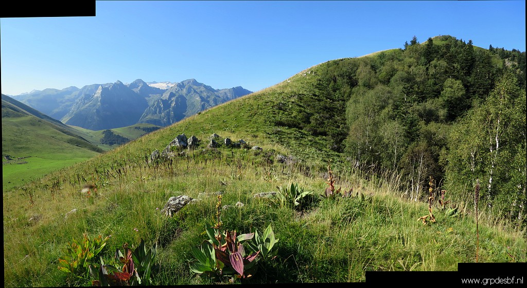
A Treaty: on the international borderline and 100m from bm333 at Cap de la Picada Photographed on 20180819 (more pictures on that page) The markers A to F left no doubt for the commission. In general they are along the 'precipice' - west of the borderridge - between Pic de la Picada (bm333) and Pas de Ribesettes (west of Pic de Ribeshautes, bm339). |
| 'Precipice' might be a bit exaggerated but it's a sudden steep descent, well recognizable in the field. The commission just followed that curving edge and measured the distances mentioned in the treaty. | |
|
B Treaty: at 360m from A where de rim of the escarpment makes an unmistakeable angle from the side of Carabidos Photographed on 20180819 (more pictures on that page) One can clearly distinguish the steep descent to the west (= left on this picture), too steep for cattle to descend. |
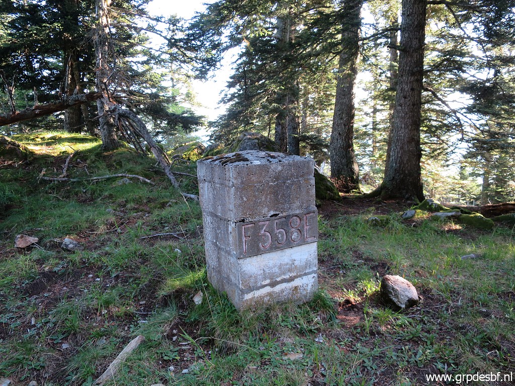 |
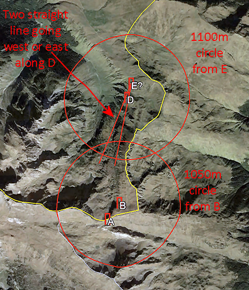
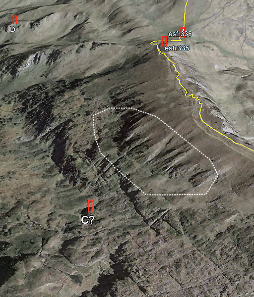
C, not found by Charles & Josette & Paco Treaty: at 1050m from B at a small hilltop ("piton du Sapin") But soon after B, the 'precipice' becomes less distinct or there seem to be more than one 'precipices', parallel to each other. Which line of which 'precipice' took the commission? Knowing that D is quite downhill, I think they took the lower ones. |
 |
Sermet writes that is was necessary to lower the marker C by cords
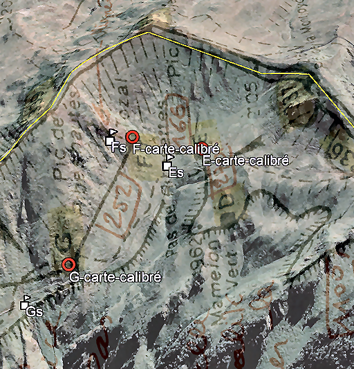
because the descent was inaccessible for the mule. That description might make identification of the Piton du Sapin easier. Apparently it was a distinct hilltop visible from above. But there is more information: - the straight line from C to Pas de Ribesettes (E) passes on a short distance D, thus either west or east of it - the distance from B was measured as 1050m - the distance from E was measured as 1100m If we draw these data on Google Earth, we get a limited area where probably C was placed. Update 2021 On Sermet's map, marker D is located ± 250m SE of it's actual position. Marker E (not found yet) is on Sermet's map ± 500m SE of the spot I figured out. |
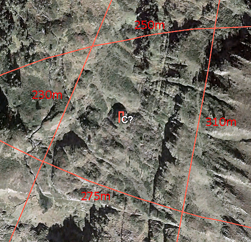 |
And this is a zoom-in of that trapezoid-like area with the distances of its sides. If we look at tha area closely, we can see more hilltop-candidates, especially in the SE. Only in the field one can - I think - distinguish the small hilltop ("piton du Sapin") of the Treaty. If on the hilltop of C? there's no marker, one could search within a circle of 225m from the waypoint of "C?" to cover this trapezoid. Update june 2020 I searched on 20-6-2020 for marker C at the spot as estimated above. I concluded at the spot itself that that position was far too below in respect to the mountainridge. |
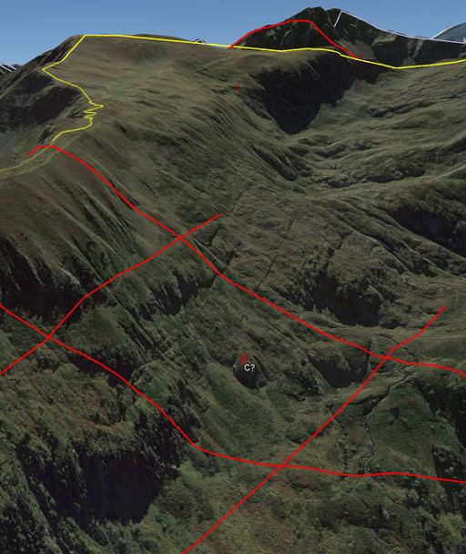 |
The area to search in 3D on Google Earth, seen from the south. Update june 2020 I searched on 20-6-2020 for marker C at the spot as estimated above. I concluded at the spot itself that that position was far too below in respect to the mountainridge. |
|
Update june 2020: I searched on 20-6-2020 for marker C at the spot as estimated above. I concluded at the spot itself that that position was far too below in respect to the mountainridge. This can not reasonably be fitted in the account of Jean Sermet of the reinstallment of this marker. Jean Sermet writes that is was necessary to lower the marker C by cords because the descent was inaccessible for the mule. He doesn't make any remark about it being installed very much lower than the ridge and with more difficulties than just lowering the marker by cords. Conclusion: more likely is a position higher on the mountainside as indicated by the white circle on this picture. |
| Update 2021: The recently acquired map of Jean Sermet (see the Sources-section above) shows also the position of marker C. When this map is projected as an overlay on Google Earth we see this: 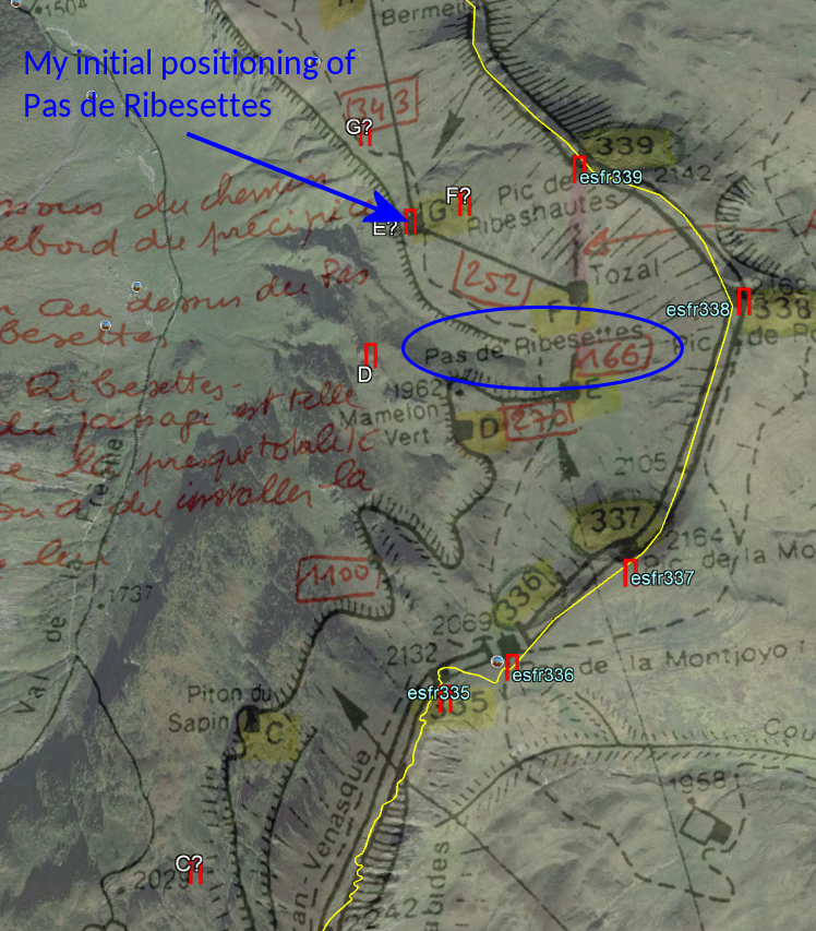 But what is disturbing about this map: marker D (found in 2018) is in fact located ± 250m NW of the spot indicated at this map. Has it been relocated in later years by the Spanish shepherds to enlarge their 'pacage'? |
|
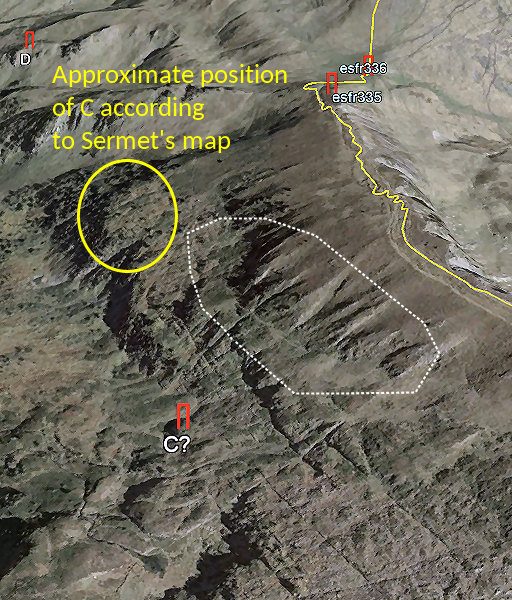 |
Projection of the position of C on Sermet's map on the Google Earth-screenshot from above. That makes more sense as being on the "Piton du Sapin", a small hilltop with pine trees. |
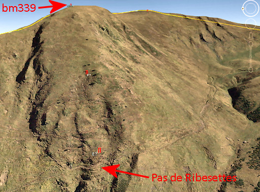 |
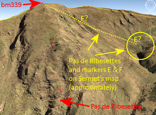
Pas de Ribesettes The toponym 'Pas de Ribesettes' is absent on the current maps but from Sermet's article we learn that it is the passage of the trail from bm336 (Pas de la Mounjoye) to the Cabane de Campsaure at a very steep part of the hillside. It is located west of bm339. |
 |
Update 2021 Sermet's map shows a completely different location of the Pas de Ribesettes. Thus also from the supposed positions of markers E and F. See hereunder. |
 |
D Treaty: 1100m further on a small rounded green hilltop and close to the straight line from piton du Sapin (C) to Pas de Ribesettes Photographed on 20180819 (more pictures on that page) |
 |
Update 2021 The problem with marker D is that its actual position cannot be matched with the description of "close to the straight line from piton du Sapin (C) to Pas de Ribesettes" AND with the position on Sermet's map: it is in fact located ± 250m NW of the spot indicated at this map. |
|
E, not found by Charles & Josette & Paco Treaty: towards the middle of Pas de Ribesettes, 15m above the trail which goes along the precipice and 270m from the hilltop of D following the upper line of the escarpment E (as well as F) are well described in the treaty: between Pas de Ribesettes and bm339. E was thus replaced above the Pas de Ribesettes. |
|
As said before: the 'Pas de
Ribesettes' is the passage of the trail
from bm336 (Pas de la Mounjoye) to the Cabane de Campsaure at a very
steep part of the hillside. Update 2021 This is the position of Pas de Ribesettes estimated by me in 2019. |
|
|
Update 2021 But Sermet's map shows a completely different location of the Pas de Ribesettes. Thus also from the supposed positions of markers E and F. See hereunder. |
|
F, not found by Charles & Josette & Paco Treaty: on the direct line from E to Pic de Ribeshautes (bm339) and well on the "Tozal de Ribesettes" which is 166m from E and 267m from Pic de Ribeshautes |
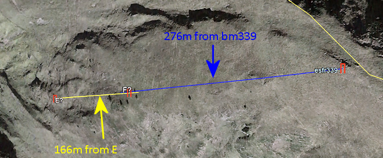 If we draw 2 straight lines in Google Earth (measuring distances on the ground) of 166m from E towards bm339 and 267m from bm339 towards E, there is an overlap of ± 25m. There are a few solitary trees at that spot. One can expect to find F (if it still exists) in that overlap. From the Pas de Ribesettes it would be a steep climb of 200m elevation. Update 2021 As pointed out above, these are wrong positions according to Sermet's map because the Pas de Ribesettes is located ± 500m SE of what I thought in 2018. It should be like this: 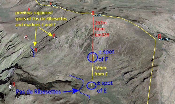 |
|
|
G, not found by Charles & Josette & Paco Treaty: 252m to the north and 34m from the precipice at the "Palo de Ribesettes" or "Coume de Riéra" Sermet writes: beyond the Pas de Ribesettes the landscape widens again. Marker G was placed below the trail and at a distance of 34m from the 'precipice'. Update 2021 When re-reading this Treaty-phrase, I realise that "Palo de Ribesettes' must be the steep hillside where I expected Pas de Ribesettes to be in 2019. |
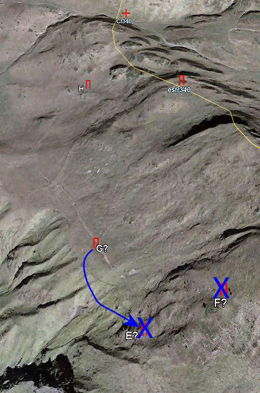 |
Both distances projected at Google Earth give a close estimation of the spot of G. Update 2021 As explained above, the markers E and F above the Pas de Ribesettes are located ± 300m to the S because the Pas de Ribesettes is at another spot than previously assumed. The marker G was placed approximately where previously marker E was expected. |
 |
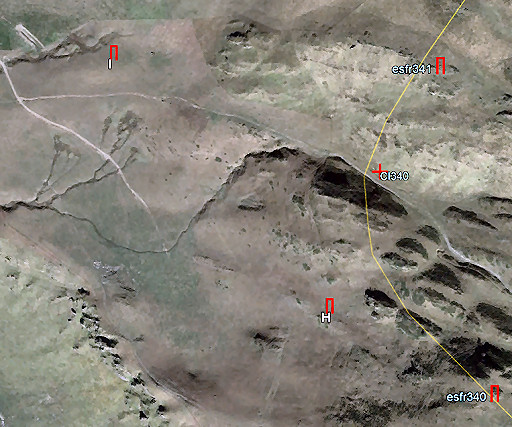
H Treaty: from G until K, the demarcation line goes NW with H at 343m in that direction and 44m from the foot of the "Pierre-Vermeille at the international borderline, close to bm340 Photographed on 20180819 (more pictures on that page) |
 |
Sermet
writes that he villages of Bénon,
Bégos and las Bordas enjoyed abundant pastures (including the valley of
Roumingou which was since long Spanish territory) with an unrivalled
supply of water. Thus no space for a mild approach of the demands of the Spanish shepherds. One senses Sermet's irritation when the Las Bordas-delegation let the delegation wait for hours to first visit Hospice de France for drinking and eating. H is close to bm340 and 44m from the foot of the Roca Vermella. The description of the treaty is quite precise and left no space for discussion with the shepherds. |
 |
I Treaty: : 433m further on and about 100m above the "fontaine de Roumingou", besides an ancient cross engraved at a rock Photographed on 20180819 (more pictures on that page) The commission was happy to find a cross on a little rock at ground surface, proving - they thought - the position of I. But it was far closer to the source of fontaine de Roumingou than the prescribed ± 100m of the treaty. |
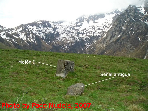 |
Picture of Paco Nudels from 2007, showing the rock nearby with the engraving. D |
 |
But Sermet's explanation was that erosion had cause the source to move
uphill. The Spanish didn't protest because they gained some square
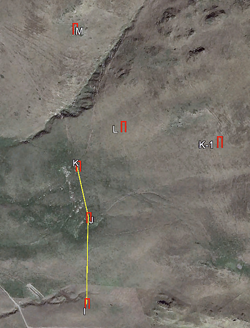
meters of terrain. And Sermet admitted: the straight line from I to K (treaty) now became a broken line to K bending at J. That is because J was kept in the place the commisson had measured. |
 |
J Treaty: 206m further on, close to an ancient cross engraved at a rock Photographed on 20180821 (more pictures on that page) Sermet writes that this marker (not finding the rock with the ancient marker which the treaty mentions) was kept in the measured place despite the request of the Spanish to put it more to the west. But they still gained some square meters because of the more western placement of I. |
 |
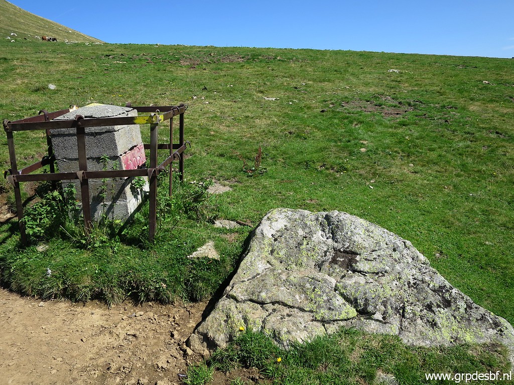
K Treaty: 113m further on, next to a rock with an ancient engraving Photographed on 20180821 (more pictures on that page) In 1957 the concrete base of K was found back, next to a rock with an ancient engraving. No discussion here. |
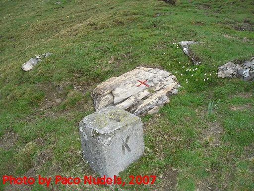 |
Picture of Paco Nudels from 2007, showing the cross on the rock. |
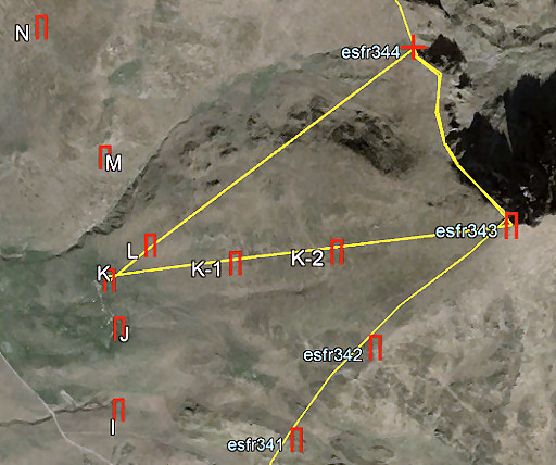 |
The markers K' and K'' were placed to demarcate a peculiar triangle on the hillside. In that triangle the communities of Bénon,
Bégos and las Bordas had the sole use of the terrain. The rest of their pastures were in
common use ('compascuité') with the shepherds of Bagnères-de-Luchon. The triangle was demarcated by K via K' and K'' to bm343, then along the border to 344, then going straight back to L and K. Apparently the marker L was placed in 1959 about 50m to the NW from its current position. See hereunder at L. |
|
K' Treaty: 281m from K Photographed on 20180821 (more pictures on that page) With the direction and distance being fixed, it was easy to determine the right spot for K'. Though unrooted, it is still at the same spot of 2007-2009 when it was still erect. |
 |
K'' Treaty: 283m from K' and 570m from bm343 Photographed on 20180821 (more pictures on that page) With the direction and distances being fixed, it was easy to determine the right spot for K' |
 |
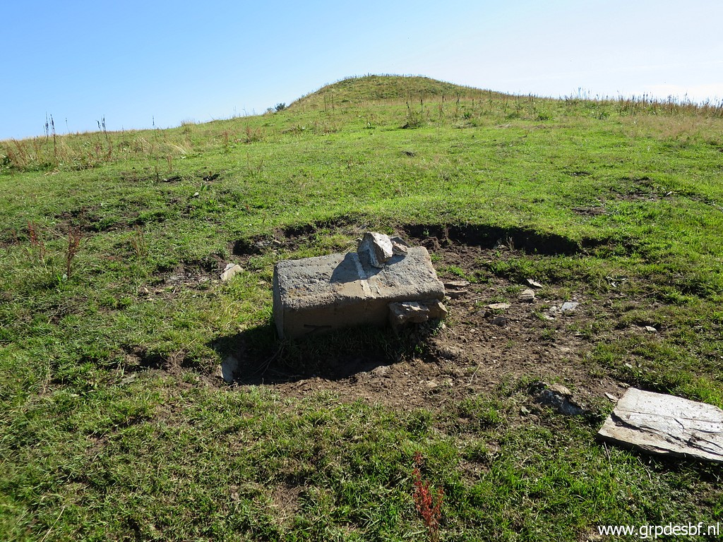
L Treaty: : in a straight line of 130m from K in an angle of 26⁰ 40' degrees Photographed on 20180821 (more pictures on that page) This marker is still at the position as Charles & Josette found them. Paco shows no picture and we don't know if it was still erect at that time. |
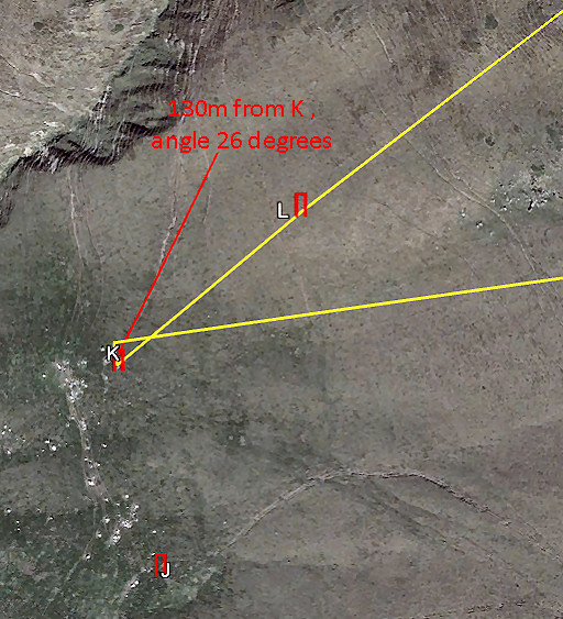 |
So the treaty prescribes for L: 130m from K in an angle of 26⁰ 40' degrees. The only time that the treaty mentions an angle... And that how the commission measured angle and distance to L. But if we draw on Google Earth a line of 130m in an angle of 27 degrees, we'll find surprsingly a different spot for L than at his current spot and well 50m to the NW and more downhill. Conclusion: the current L is not at the position where the commission planted it but 50m to the SE uphill. This relocation must have been man-made. |
There
is another interesting phenomenon. The treaty describes a straight line
from marker L to S with M, N, O, P, Q and R on that straight line.
Well: the spot of marker L could be fixed very precise because the spot
of K was considered as undisputed (the cement base of the original
marker was found back next to a rock with an ancient engraving). And
the cross R was found back. With those two fixed spots we can draw the
straight line of the treaty.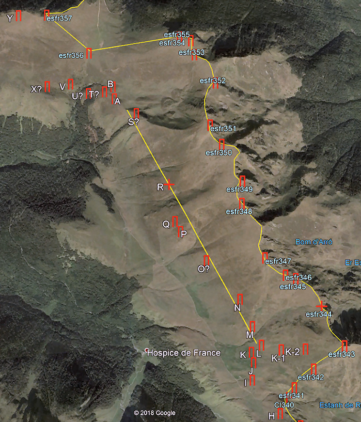 We see that the current M and N are slightly above the line while P and Q have gotten a place underneath it. But it remains a question how precise the commission could draw that straight line on the ondulating hillside. |
|
 |
M Treaty: at 378m from L, besides an ancient cross in a spot with a lot of small rocks Photographed on 20180821 (more pictures on that page) The bordercommission placed this M lower than they intended (and that was near a rock with a well-kept cross) after the Vilamos-delegation showed a rock downhill with a vague cross. The distance with L became unsatisfactory (300m instead of the prescribed 378m) but nonetheless they complied to lose no more time. |
| M was placed (my estimation) 30 to 50m south of a rocky rupture in the hillside: probably the rock at the top of this picture. Probably the place where the commission intended to place M, estimating that that was the spot of M in 1862. | |
 |
N Treaty: at 289m from M on the straight line from L to S Photographed on 20180821 (more pictures on that page) From M (which was shifted 30-50m to the south to appease the Vilamos-shepherds), the commission went to the NNW for 289m to place N, just below a path to leave that trail to the Spanish. A year later in 1960 it was degraded and slided downhill and was replaced and repaired. |
| See
also hereunder at P to read that that position of N was adjusted later to get
O more on the straight line from M to P. But still it seems above that straight line. |
|
|
O, not found by Charles & Josette & Paco Treaty: 510m from N on the straight line from L to S Sermet writes: from N onwards in the same direction after 500m, one arrives at the ravin du ruisseau de Coume-Ferme. O was planned to be placed above that ravin. Note: the treaty makes no mention of this ravin as a reference point. |
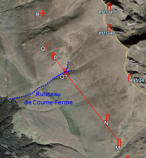 |
That ruisseau of that name
is still on the French maps but the
distance from N to O is (measured on the ground in Google Earth) ± 675m
in stead of the 510m of the treaty and the ± 500m that the commission
measured. But reading Sermet's article, there can be little doubt: O was placed at the southern rim of the ravin. But to the spot of P the distance became only 300m. But apparently that gave no concern. See also hereunder at P to read that the position of O was later adjusted to get it more on the straight line from M to P. |
 |
P Treaty: 390m further on, besides an ancient cross on a rock, meant to demarcate the terrains of Arrou and Arrès Photographed on 20180821 (more pictures on that page) Sermet writes that ± 400m beyond O, high on the hillside, there was a cross on a rock. That fitted in the treaty to be the spot of P. |
|
But
now the line M-N-O-P-Q was above some small drinking-pools and the
Arró-shepherds protested heavily. For P they proposed a rock downhill
with ancient engravings. And again the French delegation complied. But it meant that the positions of N and O had to be adjusted (thus more downhill) on the line from M to P. But strangely enough the current N is still above that straight line from N to P. |
 |
Q Treaty: 131m further on, besides a rock, at 800m from Cabane de Campsaure Photographed on 20180821 (more pictures on that page) Sermet writes that a suitable spot was found for Q besides a rock with ± the prescribed distance to Cabane de Campsaure (700m instead of the prescribed 800m) and 115m from P (instead of 132m, not surprising because the position of P had shifted downhill to please the Spanish) and 325m (in stead of 425m) from R. |
 |
These
differences were regarded as plausible because in the 19th century
distance measuring was by a surveyors-chain which followed all the
ondulations of the hillside. Anyway, Q was placed 10m north of that rock as we can see on this picture. |
 |
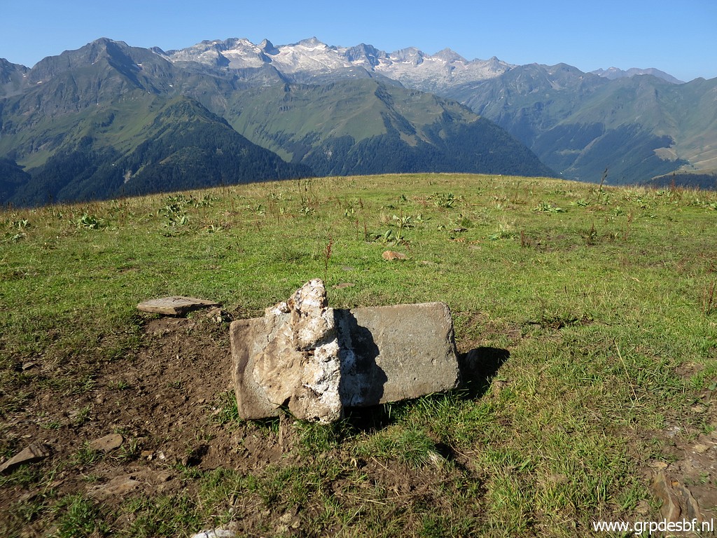
R Treaty: 425m further on, not a borderstone but a cross with double branches on the vertical side of a rock between 2 'ravines' cq gullies Photographed on 20180821 (more pictures on that page) This is the only marker which has been left from the 1860-series, it's also the only cross. It was found back in 1959 and served as a reference for the adjacent markers. |
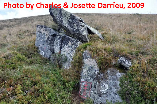 |
Picture of Charles & Josette Darrieu from 2009, showing the rock formation in spring. |
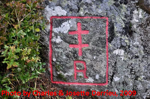 |
Picture of Charles & Josette Darrieu from 2009, showing the double cross in full glory. |
|
S, not found by Charles & Josette & Paco Treaty: 795m further on at a spot called "Barro de la Peno" on the ridge that descends from Pic d'Arrès Sermet writes: from R after 700m of measuring they reached the 'Sarrat'-ridge which descends from Pic d'Arrès and well at the upper edge of a small birch forest ("Pala del Bedoutché") which is about 100m long (and 15m wide, EB). But .... the treaty gives the name "Pala del Bédoutché" to the spot of T. That must have been a misstake of Sermet. |
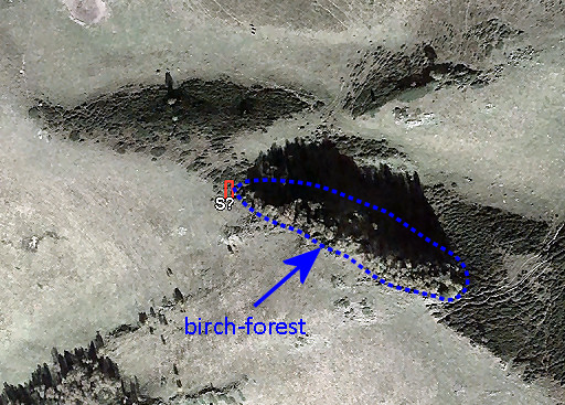 |
They decided to place S at the lower edge of the forest, this to the
vivid protest of Bosost-delegation who were - in the appreciation of Sermet -
jealous that the Arrès got more terrain by this decision. This small forest is still well recognizable on Google Earth and that makes the spot of this marker - placed in 1959 - obvious. If it's still there .... |
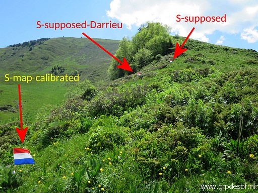 |
S The supposed location of S explored on 20210613 with no result, neither on two alternative locations (as figured out by Charles Darrieu and based on a calibrated map). (more pictures at that page) |
|
T, not found by Charles & Josette & Paco Treaty: 453m from S in the middle of several little rocks at a spot called "Pala del Bédoutché", on the ridge descending from Pic d'Arrès. With the distances from T to S (453m) and the fact that it is on the ridge descending from Pic d'Arrès, we can determine a probable spot. |
 Update 2021: but Sermet's map shows another position, not on the ridge. Quite confusing. 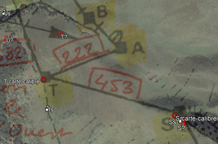 |
|
 |
T The supposed location of T based on Sermet's map explored on 20210613 with no result, neither on two alternative locations (as figured out by Charles Darrieu and by me in 2019). (more pictures at that page) |
 |
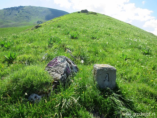
A Treaty: 440m from bm356 at a spot called "Sarrat de la Coume d'Arrès", besides an ancient cross engraved on a rock Photographed on 20180821 (more pictures on that page) A was placed in 1959 besides a rock with a fine engraving of the 'barres d'Aragon' and on the ridge descending from Pic d'Arrès NWW-NW. But the distance to bm356 was not 440m (treaty) but 570m. And there's no reference in the text of its location being on the ridge from Pic d'Arrès downhill. |
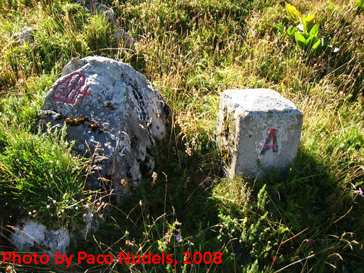 |
Picture of Paco Nudels, showing the engravings on the rock. |
 |
A Photographed on 20210613 (more pictures at that page) |
 |
Nonetheless, the bordercommission
concluded that this was the spot of the original A. They were apparently happy to find the rock with the fine engravings. By the way: the toponym Coume d'Arrès refers to the following terrain which belonged to Bossost. |
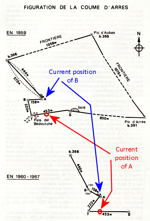 |
Later Jean Sermet wondered if there had been an error in the
Treaty-text of 1862. This because of the great difference in distance
to bm356. Had they - in 1862 - not mixed up A and B and was the spot of A meant
to be the original spot of B? In his article, he show this map (with my annotations). A few remarks: - S is shown at the western side of the small birch forest - T is shown on a spot with several little rocks, 453m from S But (the map of 1960-67) shows A at approximately the position of the current B while nowadays A is on the ridge between S and T. And the current B should have been 158m to the NW near a rock. The second sketch shows how Sermet thougt the commission of 1862 meant the broken line from bm356 to T to be. But that still doesn't make sense in the sequence of the treaty-text: - A: 440m from bm356 - B: 158m from A - T: 222m from B on the ridge descending from Pic d'Arrès |
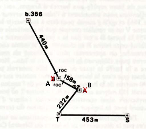 |
So let's change Sermet's sketch to the sequence of the Treaty. And that makes more sense: it was meant to be the western limit of "Coume d'Arrès" from bm356 via A to B to T on the ridge descending from Pic d'Arrès. This is - to my opinion - how the line between bm356 to T was meant in 1862. But who cares or cared? A and B demarcate the division between the pastures of Bossost and Bagnères-de-Luchon. But because they had mutual rights of grazing on either side of that division, the exact line of division was of little interest to the shepherds. |
 |
B Treaty: 158m from A at a spot called (by the Spanish) "Clot de la Coume d'Arrès" Photographed on 20180821 (more pictures on that page) This marker - placed in 1959 - was relocated in 1967 after Sermet and Alija in 1960 came to the hypothesis that the treaty of 1982 had -by error - exchanged the intended spots of A and B. |
|
This resulted in 1967 in a relocation of B to his current spot, ± 135
to the east and in that position 440m from bm356. But that was in the
Treaty the distance for bm356 to A. The marker A was left in his
position besides the marker with the 'barres d'Aragon' and on the ridge descending from Pic d'Arrès with downhil T and uphill S. |
|
|
U, not found by Charles & Josette & Paco Treaty: at 382m descending by the same ridge at a spot called by the Spanisch "Paleta den Berns" Marker U was placed in 1959 at a time when the exact spot of V was not yet known. In 1960 - after the discovery of the rock with ancient engravings determining the spot of V - the bordercommission decided that the spot of U was still sufficient fitting in the Treaty. |
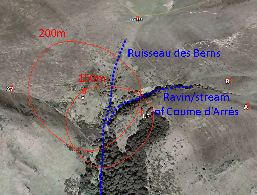 |
It was
150m east of the Ruisseau des Berns (± 200m from V) and south of a
ravin with a stream coming from Coume d'Arrès. It was placed in a small
'prairie' at the edge of a forest covering a rocky gap and at the lower
end of the ridge, descending from 'Pala del Bédoutché with T. If we try to project these directions and distances on Google Earth, the result gives an approximate location of U. |
 |
Update 2021 Very confusing: Sermet shows on his map a position 160m to the N of the above estimated location and not matching the description mentioned. |
 |
U The supposed location of U bases on Sermet's map explored on 20210613 with no result, neither on two alternative locations (as figured out by Charles Darrieu and by me in 2019). (more pictures at that page) |
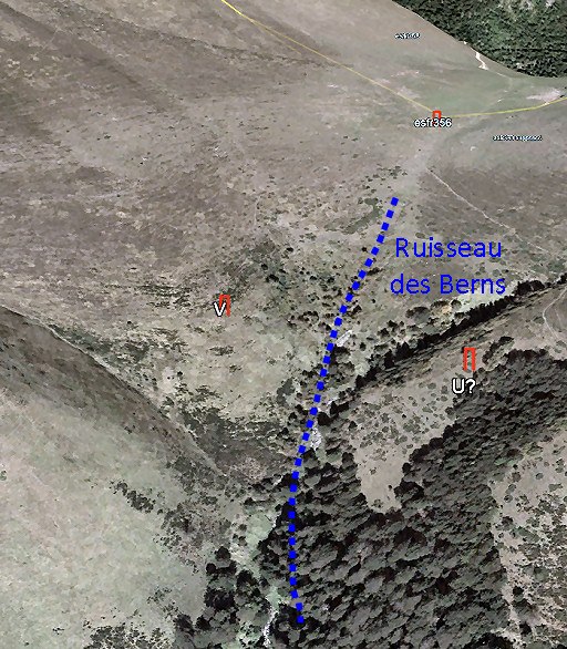 |
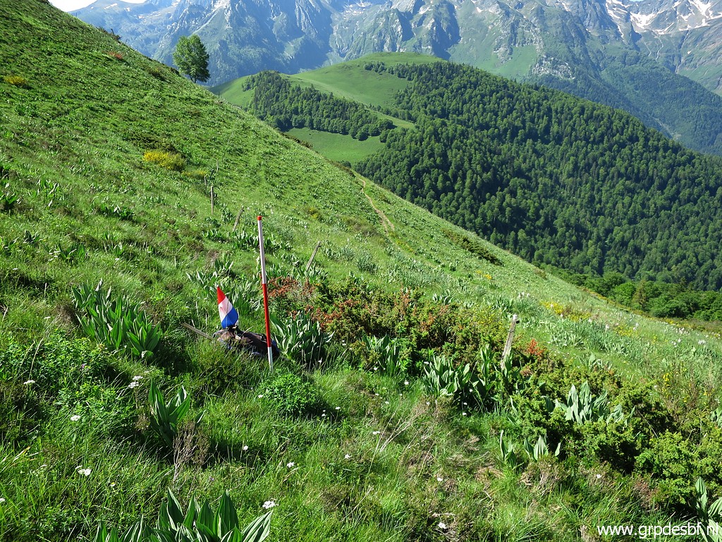
V Treaty: 200m further on, beyond the Ruisseau des Berns on the lower part of the hillridge ("contrefort") that descends from Plan de la Serre and next to a rock upon which an ancient sign is engraved The spot of V couldn't be identified in 1959 because the rock nearby with an ancient engraving could not be found. V and X were placed in a arbitrary way, all the more because the surveyor's cord was stolen. This had to be corrected next year, V and X had by then already disappeared. But then a shepherd revealed the position of the unfindable rock near V. And that made a correct localisation for V possible. |
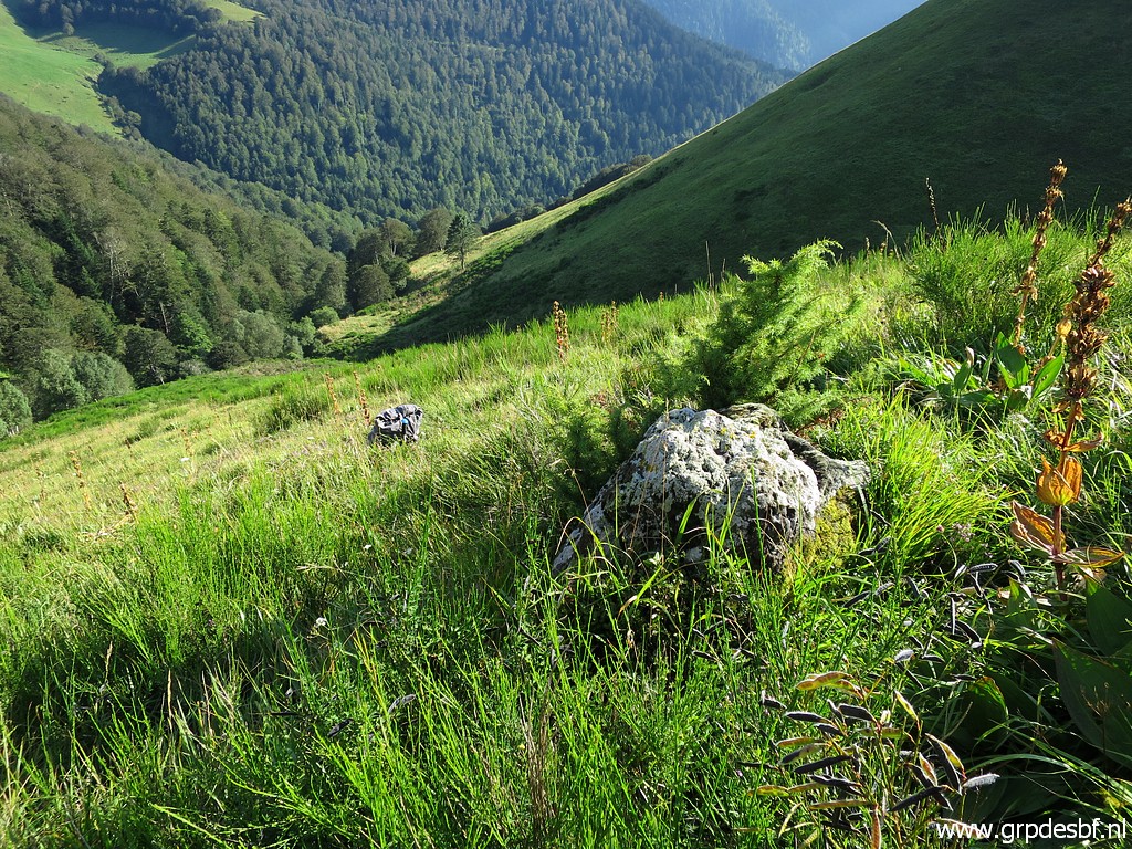 |
V - rock with ancient engravings Photographed on 20180820 (more pictures on that page) And this is that rock. A bit lower you can see my backpack at the spot of V. One was surprised to find on that rock the 'barres d'Aragon' and a 'fleur de Lys', the same as on the rock besides bm356. |
 |
V, hidden in the grass V was planted approximately 10 meters below that rock. |
W - this letter was for some reason omitted in the alphabetical sequence. |
|
|
X not found by Charles & Josette & Paco Treaty: from V 212m climbing up that hillridge ("contrefort") at a spot called by the Spanish "Loucéra" close to another rock wih an ancient engraving The final identifcation of the spot of V made immediately clear which 'contrefort' - a slight ridge leading to Y at the summit of Tuc du Plan de la Serre - was meant in the treaty. Measuring a distance of 212m uphill along the 'contrefort' was easy enough although the rock with an ancient engraving was not found. |
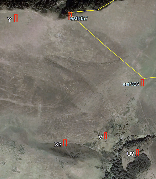 |
However: the
distance from that spot to Y proved to be 550m instead of the 700m from
the treaty. That was clearly incompatible. The commission adopted a compromise for the location of X: more to the west at the beginning of a ravine at the division with the next 'contrefort'. The distance to V became 250m and the position of X was 'hardly higher', resulting in a distance of almost 700m to Y. The Bosost-shepherds were thankful for this extension of their terrain, compensating for the unexpected discovery of the rock near the spot of V which had limited their claims. They even revealed that the spot of X was the place called "Lucera" in the treaty! But that is unlikely because this spot is not on the contrefort from V to Yand would have supported their claims for extension of their pastures. So no need for hiding. |
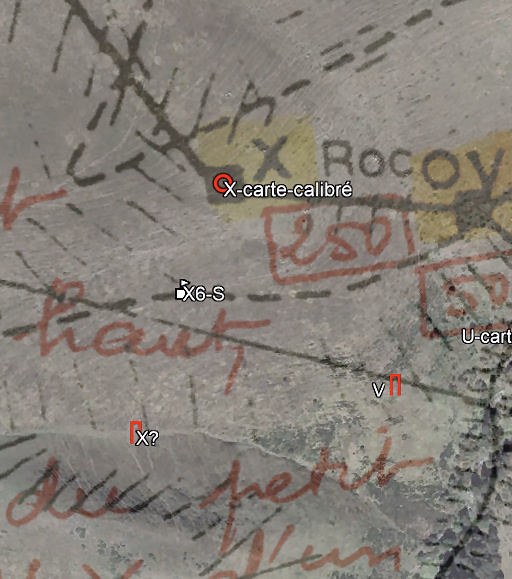 |
Update 2021 If we look closely at the calibrated map of Sermet, we can draw 2 conclusions: 1. Marker V on the map is at another position than the V found in the terrain. That is plausible: the rock indicating the position of V (as explained above) was found later. V was then replaced. That proves that this map is not the final map of the placement of the bornes de pacage but an intermediate draft. 2. marker X was not placed on the 'contrefort' (ridge) from V to Y (as the treaty describes) but to the south at the beginning of a ravine. In this way the intermediate distances to V and Y would match better with the treaty. That means that 'X?' is the best estimation of the location of X. |
 |
X The supposed location of X explored on 20210611 with no result, neither on two alternative locations (as figured out by Charles Darrieu and based on a calibrated map). Reading the information above, I could have searched more uphill where this ravine starts. (more pictures at that page) |
 |
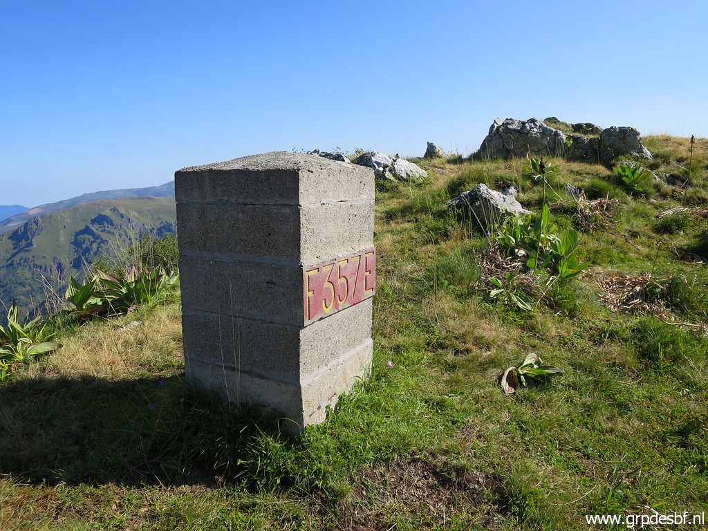
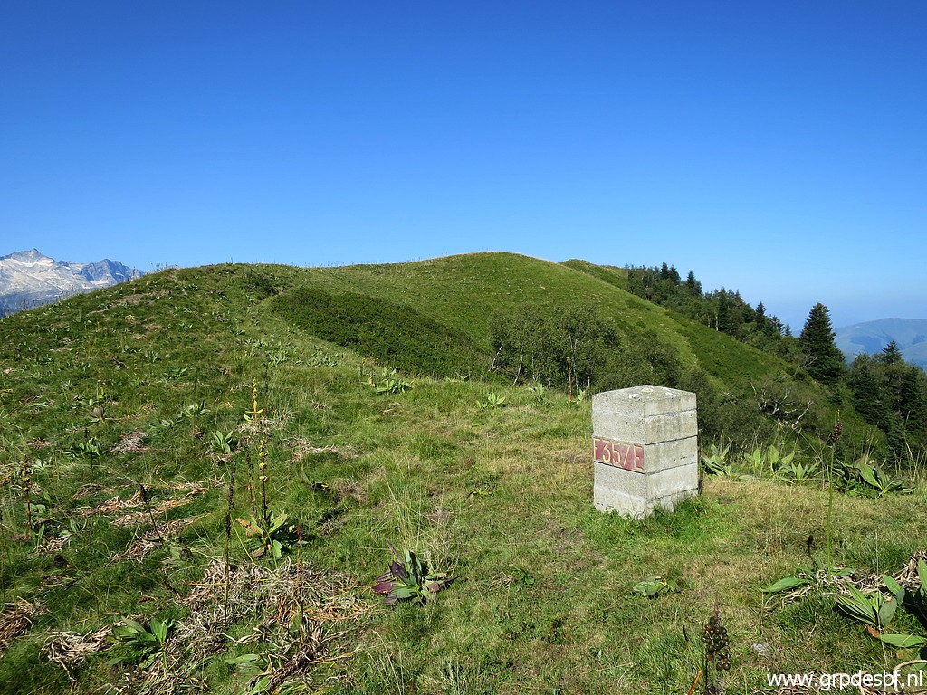
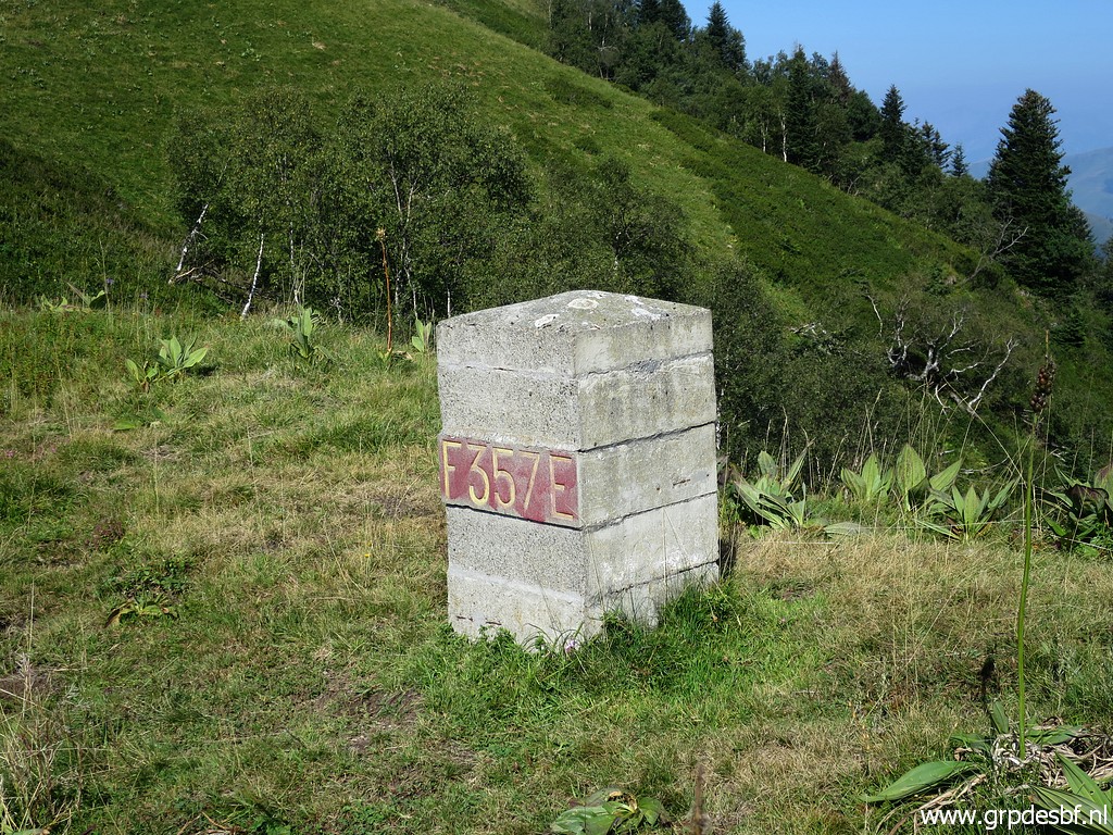
Y Treaty: at 735m from X while further climbing the hillridge ("contrefort") and 270m from bm357 Photographed on 20180821 (more pictures on that page) Around 2008 still erect, now still at his original position. Y is at the broad summit of Tuc du Plan de la Serra, 270m away of bm357. It was placed in 1959. |
|
Y, view to the south. By the way: Sermet writes that Y is at the top of the 'contrefort' from V via X to V. However, this pictures shows that Y is at the broad and flattened summit of the mountain. Sermet defends the position of bm357 - not at the summit but ± 250m to the east at the ridge - for several reasons. The head of the Spanish delegation - M. Alija - had proposed to put bm357 on the summit itself (Tuc du Plan de la Serre) as the treaty prescribes, if you read it literally. This is an interesting discussion: see this blog-post. |
| The shepherds of Bosost wanted Y more to the west, 100m, near a cross. But the commision refused: the distance to bm257 would be too long and the Treaty mentions no cross as a reference for Y. | |
| next page |
|