|
The
bordermarkers of the
Pyrenees : curiosities
& trivia
 |
| There are 723 bordermarkers (I
think) It seems so simple: no. 1 is near Hendaye in the Basque country, the last one is no. 602 at the mediterranean coast. So there are 602 bordermarkers. But no, there are many more. See this page for a full explanation.  Llivia: a
spanish enclave Llivia: a
spanish enclaveThe following text is part of the special Llivia-page Llivia is situated 1 km from the Spanish border en about 20 km east from Andorra. It's size is 12 square km and the village of Llivia has 1200 inhabitants. In roman times Llivia was an important place in the region. In the middle ages a castle was built on the hill above the village (now ruined). Puigcerda, just across the current Spanish boundary, had become the primary town in the Cerdagne, which belonged as a whole to Spain. For what ever reason, Llivia received city rights from the Spanish king which turned out to be crucial in later days. In 1659 the Spanish-French border was established in the treaty of the Pyrenees. In the treaty of Llivia (1660) the half of Cerdagne including 33 villages was given to France. Spain however refused to hand over Llivia, simply because it was a city and not a village. That's how Llivia became an enclave. The exact demarcation of the French-Spanish border was undertaken in the 19th century. Llivia got his own range of 45 bordermarkers. Until then the municipal border of Llivia was considered as the international border but there were many conflicts. One centuries-old stone however (Pedra Detra, on the spot of the current marker nr. 1) was recognized on both sides as a border marker. 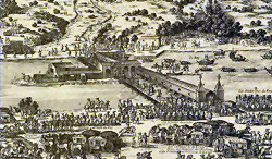 l'Île
de la Conférence - a condominium since 1659 l'Île
de la Conférence - a condominium since 1659A condominium is a piece of territory shared by two nations. The "Isle of the conference" (or 'Pheasant island' or 'l'île de Faisans') is a small island in the Bidassoa-river close to the Atlantic coast. At that place the Bidassoa is the border between France and Spain. Thus situated in the middle of a border-river, it seemed the perfect location for signing the Treaty of the Pyrenees in 1659 between the two adjoining nations. Also for Spanish-French royal couples as a first meeting place and for exchanging hostages. 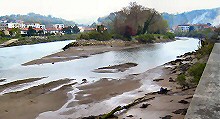 In the
Treaty of Pyrenees this island received its special status of a
condominium. There are more condominiums in the world but this one is
unique. It's unique because its sovereignty changes every six months
from Spain to France and back again. In the
Treaty of Pyrenees this island received its special status of a
condominium. There are more condominiums in the world but this one is
unique. It's unique because its sovereignty changes every six months
from Spain to France and back again.The island cannot be visited but on the Spanish side the water is undeep and an approach seems possible there with low tide. 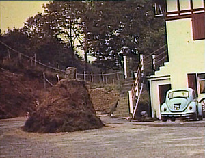 An unidentified bordermarker An unidentified bordermarkerIn spring 2011 I received a documentary on Jean Sermet ("L'homme de la frontière''). Jean Sermet was an erudite French bordermarker-commissionary who did a great job in surveying and maintenance. In the documentary we see Jean Sermet while showing slides of bordermarkers. This slide puzzles me: no number or location was mentioned and I can't identify the bordermarker. The peculiar situation shown here is not existant any more (I would have found it) but where is it and concerning which bm? I guess it's in the Basque country, white houses being so common there. Apparently, part of the hill-slope has been removed to build this parking-lot but they were not allowed to move the bordermarker. Who can help me? Well, Robert Darrieumerlou did: he solved the mystery. See this blog-post. Pays Quint - spanish soil, solely for the French 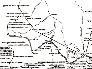 (For the original & full
map: click here ) (For the original & full
map: click here )The valley of Baïgorry was a common land since the Middle Ages. No continuous use was allowed. But in later centuries shepherds from either the north (the French village of Saint-Etienne-de-Baïgorry) or the south (the spanish valley of Erro) started to build illegal farms which were regularly demolished by the French authorities. As the competition between the villages on either side of the border for the access to the pastures grew fiercer, the national authorities became involved in the 18th century. After intense negotiations the Treaty of Elizondo (1785) was signed. It established the so-called "ligne d'Ornano", two straight lines as the new borderline, neglecting the watershed which is more to the south. The first line is from bm130 to the summit of Ichterbegui, the second from this summit to bm155 (these bordermarkers however date from 1856 or later). So the valley was artificially divided in two distinct pastoral areas. The north-side of the Ornano-line was reserved for the Baïgorry shepherds. The inhabitants of the Erro-valley got the usufructuary use of the southern part. However, the disputes went on and were only resolved with the Bayonne treaty of 1856. In that treaty, the Ornano-line was established as the final borderline as it is still up to this day. It allowed the French shepherds to live and build farms on both sides of the Ornano-line while the Spanish shepherd were restricted to only grazing their flocks in the summer. So the French shepherds were favored but France agreed to pay an annual payment which they still do. The 'Pays Quint' is the part between the Ornano-line and the watershed. It is Spanish territory but its use for farming and housing is primarily meant for French citizens. The treaty (article 16) gives them the perpetual right of grazing between the new boundary line and the ridge (watershed) further south. This perpetual right is apparently exceptional in international law. According to Jacques Koleck eight French families remain in this situation. They pay property taxes to the Spanish neighboring town and the Guardia Civil ensures their safety. But for everything else, they act as if they were in France, that is to say for civil affaires like birth, marriage, death and elections, they depend on the French village of Urepel. They are also attached to France for taxes, social security, education, health services, mail, electricity. 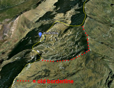 Borne 420bis Borne 420bisAn additonal bordermarker, placed in 1997. A strange story involving a correction of the French-Spanish border in the high mountains near Mount Valier. France lost about 400 hectares to Spain in a territorial claim. What happened? An officer of the geographical service of the Spanish army discovered that the borderline on the French maps at that spot - near the 'passage de la Lègne', 2503m - was situated too far to the south. At this remoted spot, there's a sort of bassin (known as "cuvette de Renadge d'en Haut" or "Coma Gireta") and the real watershed - and that means the border in the central parts of the Pyrenees - was approximately 1 km to the north. The Spanish claim was recognized and to mark the new borderline, bm420bis was placed on 10 september 1997. The picture above shows the bassin of Coma Gireta in Google Earth, seen from the west. The 3d-feature of GE allows to recognize the bassin. Watching the bassin, a misstake seems understandable. But when examining the altitude lines on the IGN-map, it beomes clear that the cartographers simply made an error somewhere in the past. 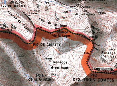 Bm420bis
is
not shown yet on the IGN-25k-maps but is indeed placed at the Passage de Lègne. See my pictures at this page Bm420bis
is
not shown yet on the IGN-25k-maps but is indeed placed at the Passage de Lègne. See my pictures at this pageMore information: - this pdf-file with an official report by J. Sermet - this pdf-file on the actual placement l'Inventaire à la Prévert (a random list of facts) - the most western bm: bm001 - the most eastern bm: bm602 - the most nothern bm: bm018 - the most southern bm: bm522 - the lowest bm: bm602 (± 5 m) - the highest bm: bm510 (± 2790 m) - the two bm's closest to each other: that's either bm305-305bis or bm574bis-575 (both ± 5 meters) but if we restrict it to the bm's mentioned in the original treaties: bm018-019 (± 10 meters). But if we include the double bm's (near Puigcerda and along the Llivia-border there is a dozen with the same number on either side of streams or a dirtroad) there are some even closer to each other (± 3m) - the two bm's that are furthest apart: bm426-427 (± 27km) Cartographic errors & omissions In the past 10 years of searching bordermarkers, I came across several discrepancies between the borderline-reality and the topographic maps. A list: Errors
Omissions
A to-do list for the CMA The CMA is the Commission Mixte d'Abornement: the Franco-Espagnol commission who supervises the check-up and maintenance of esfr-bordermarkers. If I were the chairman (a kind of "Si j'étais président") I would insist on the following priorities:
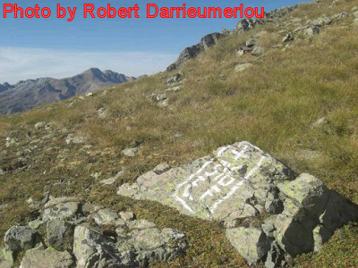 A fake-cross at Col de Lourdes A fake-cross at Col de LourdesBm316 is located at Col du Cardal. But strangely enough, at Col de Lourdes, there's another bm316. It's not engraved but painted on a rock. Why? Robert Darrieumerlou provided the answer. The Procès-Verbal states that Spanish shepherds may only pass the border at the cols with bm315, 316 and bm317 to bring their cattle to the pastures of 'Quartier de Lourdes'. But there was also a convenient route along the Col de Lourdes and that was apparently the reason to falsify bm316. Nowadays the 'transhumance' (the cross-border transfer of cattle) only takes place at Col de Bernatoire (bm317). But where is Col de Lourdes? We don't see any 'Col de Lourdes' on the various maps. It's a col between Pic de Lourdes and Col du Cardal. See the bibliograpy-page for the reference to an article by Clarens, Jean de. For more pictures of Robert: see this page. Changing toponomy: how the original bm330 was forgotten and refound In september 2012 Jean-Paul Laborie climbed to Port d'Aygues Tortes in freezing weather, his thumbs literally frozen. But he had a mission: finding the original bm330. We know that this bordercross was engraved in the 19th century at Port de Clarabide and nowadays there is still a cross 330 at this col. But that cross was engraved in 2003 because the previous one was unfindable. Jean-Paul Laborie is a “délégué à l'abornement” of the Pyrenean bordercommittee. Apparently bm330 puzzled him and at some point he got a brilliant idea. Could it be that the toponomy of the borderpasses as shown on the maps have changed in the course of years? And that the original Port de Clarabide was somewhere else? Together with Michel Bachus of the IGN cartography institute he compared old and contemporary maps: 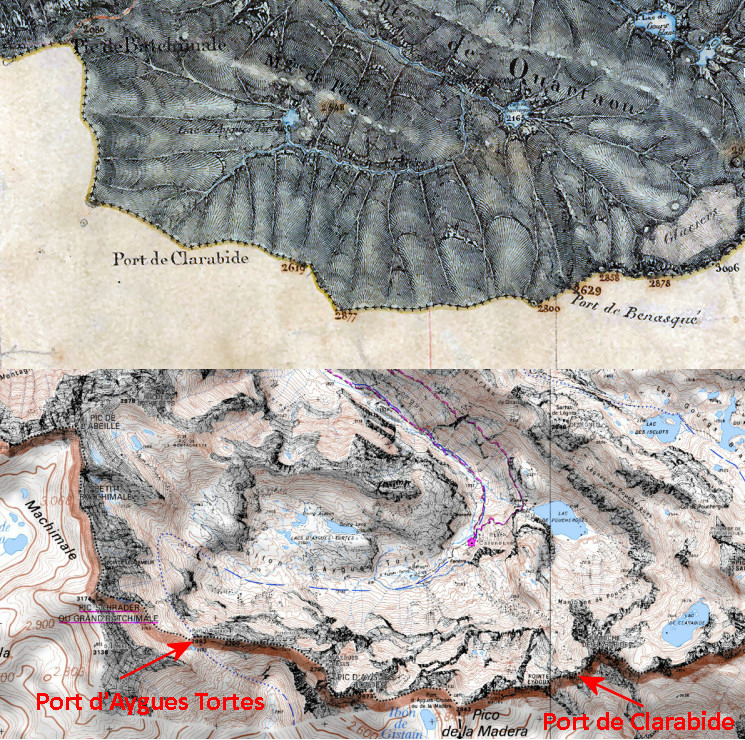 And his hypothesis was confirmed. We see that the contemporary Port d'Aygues Tortes used to be Port de Clarabide. And that's where Jean-Paul found the original bm330. For pictures of this bm: see esfr-html-markers-315-330bis.html |