|
The
bordermarkers of the Pyrenees : all my trips
 |
|
| -
tuesday 11 april
2023 - Search for Bidaubus-crosses B & C with Corinne |
 |
 |
Summary:
part of a series of 5 daytrips and one 3-days backpacking trip in april
2023. This is day 2. Today: together with Corinne Gourgeonnet from Bausen a roundtrip to explore the assumed spots of the Bidaubus-crosses B and C. Weather: sunny Basecamp: camping Pradelongue near Bagnères-de-Luchon |
<tbody>  track-20230411.gpx
This gpx-track has not been manually corrected which explains the inaccuracy and misalignment at some points. The original elevation recording has been replaced by more accurate DEM-data with Gpsvisualizer.com. For cartographic backgrounds: see the cartography-page Gps-waypoints of all bordermarkers (most recent version): kml: esfr-bordermarkers-all-waypoints.kml gpx: esfr-bordermarkers-all-waypoints.gpx (with reliable elevation data added by gpsvisualizer.com) |
|
 |
According to Garmin
Basecamp (uncorrected track with elevation added by Gpsvisualizer.com):(click photo to enlarge) Distance: 10,2 km Max-height: 1295m Min-height: 807m Elevation: +767m -770m Total elevation: 1537m Start 10:11 Finish 16:45 Total time: 6:35 |
 | Starting in the scenic village of Bausen. (click photo to enlarge) |
 | Corinne guides me to a small cemetary, Spain's smallest graveyard. (click photo to enlarge) |
 | Only one person is buried here: one Teresa. It has a tragic romantic origin, read all about it on this webpage. (click photo to enlarge) |
 | Corinne guides me on her route to Bidaubus-cross C. (click photo to enlarge) |
 | Underneath this waterpipe (click photo to enlarge) |
 | and along ruined barns (click photo to enlarge) |
 | with wide views (click photo to enlarge) |
 | we approach the assumed spot of cross C. (click photo to enlarge) |
 | A rocky sub-hilltop. (click photo to enlarge) In the 19th century four of these double branched crosses were engraved (with the letters A to D) to delimitate the southern border of the 'terrain indivis de Bidaoubous'. |
That was a slight triangular or semi-rectangular terrain on Spanish
territory south of the borderline between bm408 and 409. In the treaty
of 1863 it was described as common ground for the communities of Fos
(F) and Bausen (E).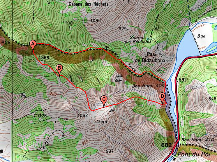 However, the exact spots of these crosses are not known. The treaty mentions toponyms which cannot be found on maps. The localisation on the map above is based on various clues, all explained on this page. But they remain hypothetical until found 'in situ'. |
|
 | We start searching the rocky terrain. Corinne has been here before. (click photo to enlarge) |
 | And there is this view to the North (click photo to enlarge) |
 | and NE to the barrage lake. (click photo to enlarge) |
 | But we find nothing. I plant my geodetical stick (click photo to enlarge) |
 | at the assumed spot which is only a rough estimation. (click photo to enlarge) |
 | Then we start climbing to cross B. (click photo to enlarge) |
 | A tough climb but for Corinne - as an experienced trailrunner - no big deal. (click photo to enlarge) |
 | Wrestling through the trees (click photo to enlarge) |
 | to the next assumed spot, roughly estimated. We check the rocks around thoroughly but to no avail. (click photo to enlarge) |
 | So we descend back along the mountainside to the trail which provides a circular trip from Bausen. We decide to complete it (click photo to enlarge) |
 | and on the other side of the mountainridge we get back to Bausen. (click photo to enlarge) |
 | Marvellous spring blossoms (click photo to enlarge) |
 | and enough old houses for sale to dream about. In Les we drink a beer and eaty chips and part until tomorrow. (click photo to enlarge) |