|
The bordermarkers of the Pyrenees : to-do list
Planning 2024
September 2024
|
Pyrénées-Atlantiques (001-311)
- nothing left to do
Hautes-Pyrénées (312-417)
- walking the
main route between 314 and 319
- redo the climb to 315 from the Spanish side
- a new search for the missing 'bornes de paçage' between bm333 and bm358
-
a new search for the bm359-cross engraved by Jean Sermet (1957). The
position of bm359 on the french IGN-map matches a lot better with the
distance of 330m from bm359 (when measured downhill taking in account
the denivellation). The cross 80m NE, found in 2009 by Paco Nudel, is
until now considered as being the bm359-cross of Jean Sermet, despite
serious doubts.
- checking a direct route from bm358 to 359 (see this page)
- a search for marker A from the 'terrain indivis' S of the bm408-409-borderline
- another search for the Croix de Malfrenor (beginning of the 'Ruissau du
Therme' between bm408 and 409). If found, it provides additional evidence that
this ruisseau was meant by the treaty as the borderline until its
confluence with the Garonne
- a survey of the hydrography around Cabane de Héréchet
Ariège (418-426)
- nothing left to do
Pyrénées-Orientales (427-602)
- bm542 once again by the classic route to see if it's still possible
|
| winter 2024-25 |
Completing the
GRPdesBF-stages on the website |
| winter 2024-25 |
Writing and
publishing my topoguide of the GRPdesBF? |
Bordermarkers - still to find or disappeared or shattered in pieces (march 2023)
Bordermarkers not found
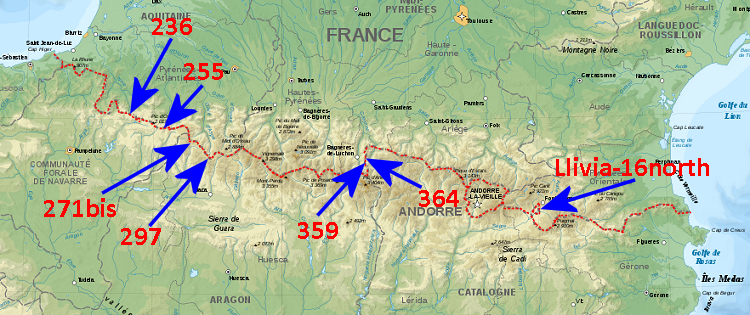
| bm236 |
 |
cross
at the summit of Pic d'Orhy, not found on 20090601, 20110817, 20170730 and 20220825, neither
by others. Official reports consider this bm as disappeared. |
| bm255 |
|
borderstone on the Port
d'Ourdayté, not found on 20090602, 20090603, 201010910, 20130902
and 20200907. There are
reports that this bm disappeared in september 2007. |
| bm271bis |
|
bm271bis is
considered to be destroyed, the site was visited on 20110828 and 20120829, 20130901 and 20220824. See 20130901
and 20220824 for an analysis of the original location of bm271bis. |
| bm297 |
|
cross engraved in a rockwall but destroyed/disappeared. The
site was visited on 20120827 and 20210616. Was 'replaced' in 1977-78 by a masonry pillar on a hilltop 175m away. |
| bm359 |
|
found on 20110901
thanks to directions of Paco Nudels and Charles & Josette Darrieu and revisited on 20140527, 20210611 and 20210917 .
However: questions remain if this is the real bm359. See this page for those questions. |
| bm364 |
|
not found on 20090610,
20100913 , 20110901
and 20150707. And
neither found by Robert Darrieumerlou,Paco Nudels, Charles & Josette
Darrieu and Jacques Koleck. Paco supplied an old
picture of the bm on this page, originating from the Archives de la
Guardia Civil. |
| Llivia bm16north |
|
Llivia has its own
set of 45 bordermarkers from which 9 are double
bm's. Somehow, I never searched for the second bm16 until 20130604 (and 20220830)
The treaty explicitly states that there are two markers no. 16. I
couldn't find the second one, nor did Charles Darrieu and Jacques Koleck. It might be removed when the road was enlarged. |
Bordermarkers disappeared in recent years
bm076
|
disappered in 2021 or earlier (see this page)
|
bm100
|
found missing in 2022 (see this page)
|
Bordermarkers still present but shattered in pieces
Varia
GRPdesBF-page
- design of the main
route
- design of the variants
- perhaps a page on
lightweight-backpacking
History-page
- more information on the actual existing delimitation from the Treaty
of the Pyrenees (1659) until the Bayonne-treaties, three centuries later
- more information on the delimitation-process in 19th century. Perhaps Sermet's "La Frontière hispano-française des Pyrénées: et les conditions de sa délimitation" can supply that
information.
- add information on the Lies and Passeries, centuries-old local cross-border
agreements on cattle grazing and mutual support and perhaps
delimitation.
Curiosities-page
- add an item on the
French hamlet of Ondarolle which religiously resides under the Spanish
church.
- draw the line of the
watershed on a map and compare it with the actual borderline.
Bibliography-section
- put local versions of
all treaties and other documents on the website itself
- extract the esfr-treaties from the "Documentos internacionales del reinado de dona Isabel II desde1842 a 1968 Parte 1
- 1869" and put these Spanish-language documents on the website
if not available elsewhere.
Cartography-page
- adding the esfr-bordermarkers and missing trails on Open
Streetmap (OSM).
Miscellania-pages
- add a page on the
morphology of the bordermarkers: on their design, their
differences and similarities
In general
- make a link down below
on the (long) pages to quickly return to above instead of having to
scroll back to the top.
|
